RAAF Base Pearce
| RAAF Base Pearce | |||||||||||
|---|---|---|---|---|---|---|---|---|---|---|---|
| Bullsbrook, north of Perth, Western Australia in Australia | |||||||||||

Lineup of PC-9 aircraft from No 2 FTS at RAAF Base Pearce
|
|||||||||||

RAAF Base Pearce
Location in Western Australia
|
|||||||||||
| Coordinates | 31°40′04″S 116°00′54″E / 31.66778°S 116.01500°ECoordinates: 31°40′04″S 116°00′54″E / 31.66778°S 116.01500°E | ||||||||||
| Type | Military air base | ||||||||||
| Site information | |||||||||||
| Owner | Department of Defence | ||||||||||
| Operator | |||||||||||
| Website | RAAF Base Pearce | ||||||||||
| Site history | |||||||||||
| Built | 1936 – 1939 | ||||||||||
| In use | 6 February 1939 – present | ||||||||||
| Garrison information | |||||||||||
| Occupants | |||||||||||
| Airfield information | |||||||||||
| Identifiers | ICAO: YPEA | ||||||||||
| Elevation | 46 metres (150 ft) AMSL | ||||||||||
|
|||||||||||
| Sources: Australian AIP and aerodrome chart[1] | |||||||||||
RAAF Base Pearce (ICAO: YPEA) is the main Royal Australian Air Force (RAAF) military air base in Western Australia, Australia. The base is located in Bullsbrook, north of Perth. It is used for training by the RAAF and the Republic of Singapore Air Force.
Pearce is the busiest RAAF base in Australia, with the highest air traffic including civil flights,[2] including civil movements at the Joint User bases. Although its primary role is pilot training, it remains the only permanent RAAF base on the west coast, and thus has a significant logistics role. Pearce also has operational responsibility for RAAF Gingin, a small military airfield located near Pearce, also used for flying training. When requested by the flying units, a rotation of air traffic controllers travel from Pearce to Gingin daily to provide services.
Contents
History[edit]
Built between 1936 and 1939, RAAF Base Pearce was officially granted "station" status on 6 February 1939.[2] It was named in honour of Sir George Pearce, a Senator from Western Australia. Pearce was elected to the inaugural Senate in 1901 and remained a Senator for Western Australia until 1938. He was Minister for Defence in four separate ministries including the period 1910 to 1913 when the Central Flying School was established.[3]
The base opened with two resident squadrons, Nos. 14 and 25 Squadrons. During World War II, No. 5 Initial Training School (ITS) was formed at RAAF Pearce as part of the Empire Air Training Scheme. Recruits commenced their military service at the ITS, learning fundamentals such as mathematics, navigation and aerodynamics.[2]
On 10 September 1950 a one-off motor race meeting, called the "Air Force Handicap" was held as a part of an RAAF air show.[4] The circuit was triangular in shape, and used all three runways of the base.[5] The feature race was won on handicap by Syd Negus in a Plymouth Special, ahead of Syd Barker in a Ballot V8 and Arthur Collett in an MG TC.[4]
Air shows[edit]
The 2005 Defence Force Air Show, held at Pearce on 19–20 November, marked the first visit to Perth of the United States Air Force (USAF) B-1B Lancer bomber. The 2012 Defence Force Air Show, held at Pearce on 19–20 May, included visits by a USAF B-52 bomber, a USAF KC-135 tanker, an RAAF AEW&C Wedgetail and an RSAF C-130 Hercules.[6]
Units[edit]
The following units are located at RAAF Base Pearce:[7]
| Unit | Full name | Force Element Group | Aircraft | Notes |
|---|---|---|---|---|
| 2FTS | No. 2 Flying Training School | Air Force Training Group | Operates PC-9 trainers | [8] |
| 25SQN | No. 25 (City of Perth) Squadron | Air Force Training Group | Air Force Reserve | [8] |
| 79SQN | No. 79 Squadron | Air Combat Group | Operates Hawk 127 fighter-trainers | [9] |
| 453SQN | No. 453 Squadron Pearce Flight | Surveillance and Response Group | Air traffic control | [10][11] |
| 1AOSS | No. 1 Airfield Operations Support Squadron Detachment Pearce | Combat Support Group | Airfield engineering | [12] |
| 1EHS | No. 1 Expeditionary Health Squadron Detachment Pearce | Combat Support Group | [12] | |
| 3SFS | No. 3 Security Force Squadron Detachment | Combat Support Group | [12] | |
| Combat Support Unit Pearce | Combat Support Group | Base managers | [13] |
The Republic of Singapore Air Force's No. 130 Squadron is also located at Pearce, and operates training aircraft.[14]
747-Mockup[edit]
The base is home to a mockup of a Boeing 747 used for counter-terrorism training[15] and has been used by the Special Air Service Regiment. Built in 2010 the mockup is smaller than an average Boeing 747 and has two non-flying engines with a fictional Emu Airlines livery.
Other uses[edit]
In 1964, Australia and the United States agreed to conduct a "Joint Research Program for Studying Aero-Space Disturbances and their Effect on Radio Communications" at the Pearce base.[16][17]
RAAF Base Pearce is used by the Australian Air Force Cadets as a headquarters and for promotional courses, as well as serving as headquarters for No. 7 Wing and premises for No. 701 Squadron (AAFC).[18] An airliner mock-up has been built on base to serve as an anti-hijacking training aid for the Australian Special Air Service's counter-terrorism squadron, also known as Tactical Assault Group (West). It is used to practise airliner entry and hostage rescue drills.
In 2014 the base was the hub for the international search of the southern Indian Ocean for Malaysia Airlines Flight 370. It hosted search aircraft from six other nations including a United States Navy P-8 Poseidon, P-3 Orions of the Royal New Zealand Air Force, Japanese Maritime Self-Defense Force and Republic of Korea Navy, and Ilyushin Il-76s of the Chinese People's Liberation Army Air Force.[19][20][14]
RAAF Base Pearce has previously been identified as the site for a second airport for Perth.[21][22]
The Republic of Singapore Air Force operates its Flying Training Institute at Pearce.[23]
Gallery[edit]
| Wikimedia Commons has media related to RAAF Base Pearce. |
-
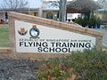
Sign for the Republic of Singapore Air Force's Flying Training School (No. 130 Squadron) at RAAF Base Pearce.
-

A Royal Air Force Avro 698 Vulcan B1A at RAAF Base Pearce in the 1970s.
-

A US Navy Douglas TA-4J Skyhawk at RAAF Base Pearce in the 1980s.


See also[edit]
References[edit]
- ^ YPEA – Pearce (PDF). AIP En Route Supplement from Airservices Australia, effective 25 May 2017, Aeronautical Chart Archived 10 April 2012 at the Wayback Machine.
- ^ a b c "RAAF Base Pearce, Australia". Airforce Technology. Kable Intelligence Limited. 2017. Retrieved 18 August 2017.
- ^ Beddie, B. "Pearce, Sir George Foster (1870–1952)". Australian Dictionary of Biography. National Centre of Biography, Australian National University. Retrieved 10 March 2014.
- ^ a b Walker, Terry (1995). Fast Tracks - Australia's Motor Racing Circuits: 1904-1995. Wahroonga, NSW: Turton & Armstrong. p. 124. ISBN 0908031556.
- ^ Galpin, Darren. "Pearce". GEL Motorsport Information Page. Retrieved 3 April 2016.
- ^ "RAAF airshow in Perth in May". Australian Flying. Yaffa Publishing. 3 April 2012. Retrieved 18 August 2017.
- ^ "RAAF Base Pearce". Royal Australian Air Force. Australian Government. Retrieved 18 August 2017.
- ^ a b "Air Force Training Group". Royal Australian Air Force. Retrieved 4 April 2014.
- ^ "No. 79 Squadron". Royal Australian Air Force. Retrieved 4 April 2014.
- ^ "Surveillance and Response Group". Royal Australian Air Force. Retrieved 4 April 2014.
- ^ "Senator Feeney celebrates the reformation of No. 452 and 453 Squadrons at RAAF Base Williamtown". Media release. Senator The Hon. David Feeney MP Parliamentary Secretary for Defence. 16 February 2011. Retrieved 4 April 2014.
- ^ a b c "Combat Support Group". Royal Australian Air Force. Retrieved 4 April 2014.
- ^ "No. 396 Expeditionary Combat Support Wing". Royal Australian Air Force. Retrieved 4 April 2014.
- ^ a b "RAAF Base Pearce". Defence Aircraft Noise, Department of Defence. Australian Government. Retrieved 18 August 2017.
- ^ Cenciotti, David (10 May 2012). "Boeing 747 mock-up used for Special Forces counter-terrorism training in Western Australia". The Aviationist. Retrieved 13 April 2015.
- ^ "Exchange of Notes constituting an Agreement between the Government of the Commonwealth of Australia and the Government of the United States of America regarding a Joint Research Program for Studying Aero-Space Disturbances and their Effect on Radio Communications. ATS 1 of 1964”. Australasian Legal Information Institute, Australian Treaties Library. Retrieved on 15 April 2017.
- ^ “Exchange of Notes constituting an Agreement between the Government of Australia and the Government of the United States of America regarding a Joint Research Program for Measuring the Physical Effects of Disturbances in the Atmosphere or in Space with particular emphasis on their effect on Radio Communications. ATS 4 of 1965”. Australasian Legal Information Institute, Australian Treaties Library. Retrieved on 15 April 2017.
- ^ "7 Wing AAFC". Australian Air Force Cadets. 2015. Retrieved 13 April 2015.
- ^ "Malaysia plane search: China checks new 'debris' image". BBC. 22 March 2014. Retrieved 22 March 2014.
- ^ "Defence supports search for aircraft". Department of Defence. 23 March 2014.
- ^ McInnes, Anita (5 June 2015). "Pearce or Gingin airport unlikely". Echo News. Retrieved 19 August 2017.
- ^ Schafer, David; Schafer, Rui (2004). "Relocation of Perth domestic/International airport north to Bullsbrook" (PDF). Infrastructure Australia. Retrieved 18 August 2017.
- ^ Zhang, Lim Min (August 21, 2017). "Republic of Singapore Air Force to train at Australia's Pearce Airbase for another 25 years under new pact". The Straits Times.
On Monday, Defence Minister Ng Eng Hen and Australian Minister for Defence Marise Payne signed the pact that will allow the RSAF to maintain and operate its Flying Training Institute in the Royal Australian Air Force (RAAF) Base Pearce for another 25 years.
External links[edit]
| Current bases including bare bases |
|
|
|---|---|---|
| Former bases |
|
|
| Overseas bases | ||
| Shared bases | ||
| Flying boat bases | ||
| Other facilities | ||