Logan International Airport
| General Edward Lawrence Logan International Airport | |||||||||||||||||||||||||||||||
|---|---|---|---|---|---|---|---|---|---|---|---|---|---|---|---|---|---|---|---|---|---|---|---|---|---|---|---|---|---|---|---|

Aerial view of Logan International Airport, before runway 14/32 was built
|
|||||||||||||||||||||||||||||||
| Summary | |||||||||||||||||||||||||||||||
| Airport type | Public | ||||||||||||||||||||||||||||||
| Owner | Massachusetts Port Authority (Massport) | ||||||||||||||||||||||||||||||
| Serves | Boston | ||||||||||||||||||||||||||||||
| Location | East Boston, Massachusetts, U.S. | ||||||||||||||||||||||||||||||
| Hub for | |||||||||||||||||||||||||||||||
| Focus city for | |||||||||||||||||||||||||||||||
| Elevation AMSL | 20 ft / 6 m | ||||||||||||||||||||||||||||||
| Coordinates | 42°21′47″N 071°00′23″W / 42.36306°N 71.00639°WCoordinates: 42°21′47″N 071°00′23″W / 42.36306°N 71.00639°W | ||||||||||||||||||||||||||||||
| Website | www |
||||||||||||||||||||||||||||||
| Maps | |||||||||||||||||||||||||||||||
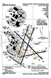 FAA airport diagram |
|||||||||||||||||||||||||||||||

BOS

BOS
|
|||||||||||||||||||||||||||||||
| Runways | |||||||||||||||||||||||||||||||
|
|||||||||||||||||||||||||||||||
| Statistics (2016) | |||||||||||||||||||||||||||||||
|
|||||||||||||||||||||||||||||||
Logan International Airport[6][7] (IATA: BOS, ICAO: KBOS, FAA LID: BOS), officially known as General Edward Lawrence Logan International Airport, is an international airport located in the East Boston neighborhood of Boston, Massachusetts, United States (and partly in the town of Winthrop, Massachusetts). It covers 2,384 acres (965 ha), has six runways and four passenger terminals, and employs an estimated 16,000 people. It is the largest airport in the New England region and 17th-busiest airport in the United States, with 33.5 million total passengers in 2015.[8] It is named after General Edward Lawrence Logan. In 2016, Massport reported an 8.5% increase in passenger traffic comparing 2015 to 2016, giving the airport a total of about 36.3 million passengers.[9]
The airport serves as a hub for Delta Air Lines and focus city for JetBlue,[2] which carries out the largest operations from Logan International Airport. The regional airline Cape Air and commuter airline PenAir all carry out hub operations from Boston. American Airlines also carries out many operations from the airport. All of the major U.S. air carriers offer flights from Boston to all or the majority of their primary and secondary hubs. It is also a destination of many major European airlines. Logan Airport has previously served as a hub for Air New England, Provincetown-Boston Airlines, American Eagle, Braniff International Airways,[10] and Northeast Airlines, as well as a focus city for AirTran Airways, American Airlines, Continental Airlines, Continental Connection, Pan American World Airways, Trans World Airlines, and US Airways.
The airport has frequent service to destinations throughout North America (including the United States, Canada and Mexico), Latin America, the Caribbean, the North Atlantic region (including Bermuda and the Azores), the Middle East, Europe, and Asia.[11] Recently, Logan has seen rapid growth in international traffic, with new routes added by airlines such as Aeromexico, Air Berlin, Air Europa, Avianca, Cathay Pacific, Copa Airlines, El Al, Emirates, Hainan Airlines, Japan Airlines, Norwegian Air Shuttle, Primera Air, Qatar Airways, Scandinavian Airlines, TAP Portugal, Thomas Cook Airlines, Turkish Airlines, WestJet Encore, and WOW air as well as increased traffic on previously existing routes to Canada, Europe, Asia and the Middle East. This has turned Boston Logan into one of America's fastest growing airports.
Contents
History[edit]

Origins[edit]
Logan Airport opened on September 8, 1923, and was used mainly by the Massachusetts Air Guard and the Army Air Corps. It was then called Jeffery Field. The first scheduled commercial passenger flights were on Colonial Air Transport between Boston and New York City in 1927.[12] On January 1, 1936, the airport's weather station became the official point for Boston's weather observations and records by the National Weather Service.[13]
Early Domestic Expansion[edit]
Until around 1950 the airline terminal was at 42.367N 71.0275W; on the 1946 topo map the airfield extended less than 5,000 ft east from there (the east end of the field was at 42.361N 71.012W NAD83). During the 1940s the airport added 1,800 acres (730 ha) of landfill in Boston Harbor, taken from the former Governors, Noddle's and Apple Islands. In 1943 the state renamed the airport after Lt. General Edward Lawrence Logan, a Spanish–American War officer from South Boston.[12][14] In 1952, Logan Airport became the first in the United States with an indirect rapid transit connection, with the opening of the Airport station on the Blue Line.
The March 1947 diagram shows 7,000 ft (2,100 m) runway 4 (future 4L) in use, with runways 9 and 33 under construction; a different runway 33 ran 6,700 ft (2,000 m) northwestward from the present intersection of 4R and 9, and runway 25 ran 4,000 ft (1,200 m) southwest from the present intersection of 4L and 33. The December 1950 diagram shows a layout similar to the current one: 7,000 ft (2,100 m) runway 4L, 10,000-ft 4R, 7,000-ft 9 and 7,650-ft 33.
Boston became a transatlantic gateway after World War II. In the late 1940s, American Overseas Airlines began operating a weekly Boston-Shannon-London service,[15] and Pan American World Airways began operating nonstop service to Shannon Airport in Ireland and Santa Maria Airport in the Azores, continuing to London and Lisbon respectively.[16] By the early 1950s, BOAC also offered nonstop Stratocruiser service to Prestwick Airport in Scotland,[17] and Air France operated a multi-stop Constellation service linking Boston to Orly Airport in Paris.[18] The April 1957 Official Airline Guide shows 49 weekday departures on American, 31 Eastern, 25 Northeast, 8 United, 7 TWA domestic, 6 National, 6 Mohawk, 2 TCA and one Provincetown-Boston. In addition TWA had nine departures a week to or from the Atlantic, Pan Am had 18, Air France 8, BOAC 4 and LAI 4.[19]
Introduction of the Jumbo Jet and Early International Expansion[edit]
The jumbo jet era began at Logan in summer 1970 when Pan Am started daily Boeing 747s to London Heathrow Airport. Currently, the Boeing 747-400 is scheduled on flights to Boston by British Airways[20] and Lufthansa. Lufthansa also operates the Boeing 747-8i on one of its daily nonstop flights to Frankfurt.[21]
When Terminal E opened in 1974 it was the second largest international arrivals facility in the United States.[22] Between 1974 and 2015, the number of international travelers at Logan has tripled. International long-haul travel has been the fastest growing market sector at the airport. Massachusetts Port Authority (Massport) undertook the "Logan Modernization Project" from 1994 to 2006: a new parking garage, a new hotel, moving walkways, terminal expansions and improvements, and two-tiered roadways to separate arrival and departure traffic.[12]
Massport's relationship with nearby communities has been strained since the mid-1960s,[23] when the agency took control of a parcel of residential land and popular fishing area near the northwest side of the airfield. This project was undertaken to extend Runway 15R/33L, which later became Logan's longest runway.[24] Residents of the neighborhood, known as Wood Island, were bought out of their homes and forced to relocate. Public opposition came to a head when residents lay down in the streets to block bulldozers and supply trucks from reaching the construction zone.[25]
Modern International Expansion and Runway Additions[edit]
Runway 14/32 opened on November 23, 2006, Logan's first major runway addition in more than forty years. It was proposed in 1973 but was delayed in the courts.[26] According to Massport records, the very first aircraft to use the new airstrip was a Continental Express ERJ-145 regional jet landing on Runway 32, on the morning of December 2, 2006.
In April 2007 the FAA approved construction of a center field taxiway long-sought by Massport. The 9,300-foot (2,830 m) taxiway is between, and parallel to, Runways 4R/22L and 4L/22R. News of the project angered neighboring residents.[27] In 2009 the taxiway opened ahead of schedule and under budget.[28] To ensure the taxiway is not mistaken for a runway, "TAXI" is written in large yellow letters at each end.

A scene from the 2006 film The Departed was filmed at Logan, inside the connector bridge between Terminal E and the Central Parking Garage. Terminal C and several United Airlines and Northwest Airlines aircraft can be seen in the background. Parts of the Delta Air Lines 2007 "Anthem" commercial were filmed in Terminal A as well as the connector bridge between Terminal A and Central Parking.
In October 2009 US Airways announced it would close its Boston crew base in May 2010. The airline cited an "operations realignment" as the reason.[29] Over 400 employees were transferred or terminated.[30]
After starting service to Logan in 2004, JetBlue Airways was a major operator at Logan Airport by 2008 and its largest carrier by 2011, with flights to cities throughout North America and the Caribbean.[31] The airline has plans to expand to 150+ flights by the end of 2015.[32]
The Airbus A380 first landed at Logan International Airport for compatibility checks on February 8, 2010. On March 26, 2017, British Airways began flying the A380 to Logan, operating the aircraft three times per week.[33]
Facilities and infrastructure[edit]

Located partly in East Boston and partly in the Town of Winthrop, on Boston Harbor,[34] Logan International Airport covers an area of 2,384 acres (965 ha) which contains six runways:[4]
- Runway 4L/22R: 7,861 ft × 150 ft (2,396 m × 46 m), Surface: Asphalt
- Runway 4R/22L: 10,005 ft × 150 ft (3,050 m × 46 m), Surface: Asphalt
- Runway 9/27: 7,000 ft × 150 ft (2,134 m × 46 m), Surface: Asphalt
- Runway 14/32: 5,000 ft × 100 ft (1,524 m × 30 m), Surface: Asphalt
- Runway 15L/33R: 2,557 ft × 100 ft (779 m × 30 m), Surface: Asphalt
- Runway 15R/33L: 10,083 ft × 150 ft (3,073 m × 46 m), Surface: Asphalt
ILS is available for runways 4R, 15R, 22L, 27, and 33L, with runways 4R and 33L are certified for CAT III Instrument Landing operations. The other runways with ILS are certified for CAT I Instrument Landing operations.[35] EMAS pads are located at the starting thresholds of runways 22R and 33L.[36]
Depending on the prevailing winds, different runways are used for takeoffs and landings:
| Wind from | Preferred Runways | Percentage of operations | |
|---|---|---|---|
| Departures | Arrivals | ||
| NE | 4L,[b] 4R, 9 | 4L, 4R | 18% |
| SW | 22L, 22R | 22L, 22R,[b] 27 | 28% |
| NW | 33L, 27 | 33L, 32, 27 | 37% |
| SE | 15R, 14, 9 | 15R, 15L | 17% |
- Notes
.jpg)
The distinctive central control tower, nearly a dozen stories high, is a local landmark with its pair of segmented elliptical pylons and a six-story platform trussed between them.
Logan Airport has two cargo facilities: North Cargo is adjacent to Terminal E and South Cargo adjacent to Terminals A and B.[36] North Cargo is also the location of several maintenance hangars, including those operated by American Airlines, Delta Air Lines and JetBlue.
Runway 14/32[edit]
Runway 14/32, which officially opened to air traffic on November 23, 2006, is unidirectional. Runway 32 is used for landings and 14 is used for takeoffs. Massport is barred by a court order from using the runway for overland landings or takeoffs, except in emergencies.[38]

There was fierce opposition towards the construction of 14/32 among communities adjacent to the northwest side of the airport, such as Chelsea and East Boston, as authorities acknowledged that these areas would likely see an increase in noise levels. Residents of Winthrop and Revere also joined in opposition, even though Massport had promised that the new traffic patterns allowed by 14/32 would reduce overflights of those areas.
Since the opening of the new runway, there has been disagreement about when, and how often, the new runway should be operational. Residents have demanded a minimum of 11.5-knot (21.3 km/h) northwest winds, slightly higher than the 10-knot (19 km/h) threshold favored by Massport.
The new runway reduces the need for the existing Runway 15L/33R, which, at only 2,557 feet (779 m) is among the shortest hard-surface runways at major airports in the United States. In 1988, Massport had proposed an 800-foot (240 m) extension to this airstrip (a project which would have required additional filling-in of land along a clam bed), but was thwarted by a court injunction.[39]
Boston's Hyatt Harborside Hotel, which sits only a few hundred yards from the runway threshold, was built primarily to prevent Massport from ever extending the length of 14/32 or using it for takeoffs or landings over the city. Massachusetts state legislators carefully chose the location of the hotel—directly in the runway centerline—prior to its construction in 1992.[40]
FBOs[edit]
The airport is served by several Fixed-Base Operators (FBO), which handle fueling, ground handling, aircraft cleaning, cargo service and aircraft maintenance. They include Swissport USA and Ground Service International. General aviation, which is adjacent to the North Cargo area, is handled by Signature Flight Support.[41]
Public safety[edit]
Police services are provided by the Massachusetts State Police Troop F. Fire protection is the responsibility of the Massport Fire Rescue.[42] Even though the airport is within city limits, by Massachusetts state law municipal police such as the Boston Police Department do not have jurisdiction on Massport property.[43]
A 250-foot security zone, established in 2002, surrounds the waters around the airport which are marked by 29 buoys indicating the restricted area. The area is patrolled by the Massachusetts State Police, the Boston Police Department, the Massachusetts Environmental Police, the United States Coast Guard and the Boston and Winthrop Harbormasters. Anyone who enters the zone for non-emergency purposes is subject to prosecution and is entered into a State Police database that tracks offenders.[44][45]
Terminals[edit]

Logan International Airport has 102 gate positions total,[46] divided among four terminals, A, B, C and E. All terminals are connected by pre-security shuttle buses and by the SL1 branch of the MBTA Silver Line BRT, as well as between Terminals A, B and E via pre-security moving walkways.[47] Moving walkways also connect the terminals to a central parking garage designed for consolidated service between all four terminals and the garage itself.[48] Massport ultimately plans to connect all terminals and gates post-security, thereby allowing for seamless connections between flights from different terminals. The concession program at the airport is developed, leased and managed by AirMall USA (formerly BAA USA) in Terminals B and E and Westfield Concession Management Inc. in Terminals A and C.
Terminal A[edit]


Terminal A, which replaced a 1970s-era building designed by Minoru Yamasaki once occupied by the now-defunct Eastern Air Lines,[49] opened to passengers on March 16, 2005. The terminal, designed by Hellmuth, Obata and Kassabaum,[50] is divided into a main terminal (housing gates A1–A11) and a satellite building (housing gates A13–A22). The main terminal and the satellite building are connected through an underground walkway.[51] The new redesigned Terminal A was developed under a special facility lease between Massachusetts Port Authority and Delta Airlines. The lease was signed on August 16, 2001 and development began. On September 14, 2005, six months after opening, Delta filed for bankruptcy and thus had to reduce the number of gates it leased in Terminal A.[52] Terminal A features two Delta Sky Clubs. One is located on the third floor of the satellite building, and a newer one opened at the site of the old Continental Airlines Presidents Club in the main terminal building.[53]
The building is the first airport terminal in the United States to be LEED certified for environmentally friendly design by the U.S. Green Building Council. Among the building's features are heat-reflecting roof and windows, low-flow faucets and waterless urinals, self-dimming lights and storm water filtration.[39]
Southwest Airlines moved to the terminal from Terminal E in April 2015 utilizing gates A18–A22 in the satellite portion of the terminal.[54]
Terminal B[edit]

Terminal B, which was designed by John Carl Warnecke & Associates and Desmond & Lord, Inc., opened in 1974.[55] Pier B was completed for US Airways in 1974 and Pier A for American Airlines in 1975.[55] The terminal remained largely unchanged until US Airways expanded its operations at Logan Airport in 1979 and improvements designed by HNTB were constructed in 1980.[55] From 1980 until 2000, numerous small projects including passenger seating area improvements, concessions expansions and passenger lounges were completed at both piers.[55][56] American's facilities were renovated in 1995 and redesigned by Gresham, Smith & Partners,[56][57] and US Airways' facilities were renovated in 1998 and 2000, and redesigned by URS Corporation with Turner Construction serving as the construction manager.[56][58]
Until 2014, Terminal B was split into north and south buildings, with a parking garage located between the two buildings. The gates of the south building (primarily occupied by American Airlines and housing an Admirals Club[59]) are divided into three groups: B1–B3, B4–B14 and B15–B19. Gates B1–B3 are the exclusive use of Air Canada. There is a single security lane for these three gates resulting in short wait times. However, to reach other gates in Terminal B including connections to Air Canada's Star Alliance partner United, it is necessary to leave the secure area and re-enter. Post-security, there is only a grab-and-go restaurant and there is no lounge access. As passengers arriving from Canada are pre-cleared by US Customs and Border Protection, passengers do not need to pass through Terminal E's international arrival facility. Gates B4–14 and B15–B19 are connected by a walkway post-security. The gates of the north building (primarily occupied by American Airlines and United Airlines, both of which operate airline lounges in the terminal[60]) are divided into two groups: B20–B36 and B37–B38. Gates B20–29 are used by United Airlines while gates B30–B36 serve American Airlines. Gates B37 and B38 are home to Spirit Airlines.[51]
Between 2012 and 2014, Terminal B underwent a $160 million renovation, which was completed in April 2014. The renovation created a post-security walkway connecting Terminal B North to Terminal B South. The renovation also included 24 new ticket counter spots, eight new departure lounges, new concession space, and a new baggage carousel.[61] United Airlines, formerly located in Terminals A and C, began operating all flights out of Terminal B starting in April 2014.[62]
Terminal C[edit]

Terminal C opened in 1967 and was designed by Perry, Shaw, Hepburn and Dean.[63] It was renovated in 1987, 2002 and 2005.[56] It has four groups of gates: C8-C10, C11–C21, C25–C36 and C40–C42.[51] The two Terminal C security checkpoints providing access to Gates C11 through C21 on the left and Gates C25 to C36 on the right were replaced by a common checkpoint on July 20, 2011.[64]
Continuing the renovations of Terminal C, a post-security connection between Terminal C and Terminal E opened in Summer 2016, allowing for seamless connections between the two terminals, part of Massport's plan to ultimately connect all terminals post-security.[65] Massport has plans to build a post-security connector between gates C8–C36 and C40–C42 which will make all gates accessible through one common security checkpoint.[66]
The former Terminal D gates (the three gates at the north end of Terminal C) were renumbered and labeled as part of Terminal E (E1C, E1D & E1E) on February 28, 2006. These three gates were used, as part of Terminal E, by Southwest Airlines until their move to Terminal A.[67] In 2016, following construction of an airside connector between Terminals E and C, these three gates were renumbered again to become the present gates C8-C10 (as part of Terminal C).
The airport's USO Lounge is located in the baggage claim area of Terminal C, lower level. It offers most typical amenities as other markets as major as Greater Boston. Military ID is mandatory.
The terminal is also home to the airport's chapel, Our Lady of the Airways, which is considered the first airport chapel in the United States. The chapel was originally Catholic, but is now non-denominational.[68][69] The chapel has existed in two incarnations. The chapel opened in 1951.[70]
The terminal serves JetBlue Airways and its partners Aer Lingus, Cape Air and TAP Portugal; it also serves Alaska Airlines, Sun Country Airlines and Virgin America.
Terminal E[edit]

Terminal E, also known as the John A. Volpe International Terminal named after the former Governor of Massachusetts and U.S. Secretary of Transportation,[12] serves as the international terminal for Logan Airport. The terminal was completed in 1974 and designed by Kubitz & Papi, Inc. and Desmond & Lord, Inc.[71] Massport completed the "Terminal E Modernization" project in August 1997 which improved the passenger facilities.[56] The International Gateway Project, designed by Skidmore, Owings and Merrill and DMJM Aviation, added 410,000 square feet to the terminal in 2003 and the entire project was completed in 2008.[56]
Terminal E has a total of 15 gates numbered E1-E12. Gates E10-E12 were recently reconstructed as part of the terminal E modernization project to accommodate Airbus A380 aircraft. In this, a second jet bridge was added to each of those three gates to make upper level boarding on the A380 possible. All gates within the terminal are designated as common-use, meaning gates are assigned mostly based on an operational need.[72] All ticket counters and gates in Terminal E are shared among the international carriers. The terminal houses several airline lounges: Aer Lingus' Gold Circle Lounge,[73] Air France's Air France Lounge,[74] British Airways' First Lounge and Terraces Lounge,[75] Lufthansa's Senator Lounge and Business Lounge[76] and Virgin Atlantic's Clubhouse Lounge.[77]
The third level of Terminal E is used for departures, the second for passport control, and the ground level for arrivals and customs.[72] The Federal Inspection Station located in Terminal E is capable of processing over 2,000 passengers per hour.[39]
Terminal E underwent a $100 million renovation which started in 2014, it includes a post-security connector between Terminals E and C (opened summer 2016), improved immigration and passport control kiosks, and gates capable of serving the Airbus A380.[78] The Terminal E expansion was completed in late January 2017.[65]
Aer Lingus used to fly their departures out of Terminal E, but due to space issues, decided to move to Terminal C, alongside their partner, JetBlue Airways. Aer Lingus uses Terminal C for all operations.
Airlines and destinations[edit]
Note: All international arrivals (except pre-cleared flights from Ireland, Canada, and the Caribbean) are handled at Terminal E.
Passenger[edit]
Cargo[edit]
| Airlines | Destinations | Refs |
|---|---|---|
| DHL Aviation operated by Atlas Air |
Cincinnati | [92] |
Logan Airport is a medium-sized airport in terms of cargo, handling 684,875 tons of freight in 2012, making it the 10th busiest airport in the U.S. in terms of cargo. It handles many U.S.-based cargo airlines, including ABX Air, DHL, FedEx Express and UPS Airlines. It also has cargo offices for many international cargo carriers, including British Airways World Cargo, Cathay Pacific Cargo, China Airlines Cargo, EVA Air Cargo, LATAM Cargo Chile and Saudia Cargo.[93] It has two cargo complexes: The North Cargo Terminal, located near Terminal E, and South Cargo, located near Terminal A.[36] Given the airport is the 10th busiest cargo facility in the country, with many companies operating at the airport, it has been recognized that future expansion of cargo from Logan is limited due to constrained physical space for expansion.[94]
Statistics[edit]


.jpg)

.jpg)

.jpg)
.jpg)
Top destinations[edit]
| Rank | Airport | Passengers | Airlines Served |
|---|---|---|---|
| 1 | Chicago–O'Hare, Illinois | 939,730 | American, JetBlue, Spirit, United |
| 2 | Atlanta, Georgia | 777,480 | Delta, JetBlue, Southwest, Spirit |
| 3 | Washington–National, D.C. | 741,980 | American, JetBlue |
| 4 | Los Angeles, California | 637,470 | American, Delta, JetBlue, United, Virgin America |
| 5 | San Francisco, California | 626,550 | Delta, JetBlue, United, Virgin America |
| 6 | Baltimore, Maryland | 596,580 | JetBlue, Southwest, Spirit |
| 7 | New York–LaGuardia, New York | 584,860 | American, Delta, JetBlue |
| 8 | Philadelphia, Pennsylvania | 578,380 | American, JetBlue |
| 9 | New York–JFK, New York | 522,850 | American, Delta, JetBlue |
| 10 | Newark, New Jersey | 503,160 | JetBlue, United |
| Rank | City | Passengers | Carriers |
|---|---|---|---|
| 1 | London (Heathrow), United Kingdom | 791,190 | British Airways, Delta, Virgin Atlantic |
| 2 | Toronto (Pearson), Canada | 450,085 | Air Canada, WestJet |
| 3 | Dublin, Ireland | 347,279 | Aer Lingus |
| 4 | Dubai (International), United Arab Emirates | 346,464 | Emirates |
| 5 | Paris (Charles de Gaulle), France | 344,087 | Air France, American, Delta |
| 6 | Reykjavík, Iceland | 334,435 | Icelandair, WOW air |
| 7 | Frankfurt, Germany | 273,197 | Lufthansa |
| 8 | Amsterdam, Netherlands | 255,965 | Delta |
| 9 | Toronto (Billy Bishop), Canada | 196,029 | Porter |
| 10 | Zurich, Switzerland | 179,885 | Swiss |
| 11 | Munich, Germany | 145,972 | Lufthansa |
| 12 | Istanbul, Turkey | 140,412 | Turkish |
| 13 | Shannon, Ireland | 130,466 | Aer Lingus |
| 14 | Beijing, China | 129,695 | Hainan Airlines |
| 15 | Montreal, Canada | 122,976 | Air Canada Express |
| 16 | Oranjestad, Aruba | 121,261 | JetBlue |
| 17 | Doha, Qatar | 120,783 | Qatar Airways |
| 18 | Hong Kong | 112,378 | Cathay Pacific |
| 19 | Tokyo (Narita), Japan | 112,214 | JAL |
| 20 | Rome (Fiumicino), Italy | 109,628 | Alitalia |
[edit]
| Rank | Carrier | Passengers | Share |
|---|---|---|---|
| 1 | JetBlue Airways | 9,046,000 | 30.46% |
| 2 | American Airlines | 6,454,000 | 21.73% |
| 3 | Delta Air Lines | 3,713,000 | 12.50% |
| 4 | United Airlines | 3,682,000 | 12.40% |
| 5 | Southwest Airlines | 3,005,000 | 10.12% |
Annual traffic[edit]
| Passengers | Change from previous year | Aircraft operations | Cargo (tonnage) |
|
|---|---|---|---|---|
| 1998 | 26,526,708 | 507,449 | 701,921 | |
| 1999 | 27,052,078 | 494,816 | 712,084 | |
| 2000 | 27,726,833 | 487,996 | 726,174 | |
| 2001 | 24,474,930 | 463,125 | 672,399 | |
| 2002 | 22,696,141 | 392,079 | 694,805 | |
| 2003 | 22,791,169 | 373,304 | 672,419 | |
| 2004 | 26,142,516 | 405,258 | 679,637 | |
| 2005 | 27,087,905 | 409,066 | 670,759 | |
| 2006 | 27,725,443 | 406,119 | 639,534 | |
| 2007 | 28,102,455 | 399,537 | 652,654 | |
| 2008 | 26,102,651 | 371,604 | 621,567 | |
| 2009 | 25,512,086 | 345,306 | 666,888 | |
| 2010 | 27,428,962 | 352,643 | 670,190 | |
| 2011 | 28,907,938 | 368,987 | 684,606 | |
| 2012 | 29,325,617 | 354,869 | 684,875 | |
| 2013 | 30,318,631 | 361,339 | 691,229 | |
| 2014 | 31,634,445 | 363,797 | 695,123 | |
| 2015 | 33,449,580 | 372,930 | 684,970 | |
| 2016 | 36,288,042 | 391,222 | 703,786 |
For the 12-month period ending January 31, 2010, the airport had 337,229 aircraft operations, an average of 924 per day: 62% scheduled commercial, 33% air taxi and 5% general aviation.[4]
As of 2010, Logan is the 19th busiest airport in the United States with about 13.5 million boardings a year (not counting arrivals). In 2010, Logan was the world's 28th busiest airport in terms of aircraft movements. The airport is also the 12th busiest airport in the U.S. based on international traffic. In 2010, it handled 3,681,739 international passengers.[5] In 2012, it handled 4,350,597 international passengers, a 9.8% increase from 2011.[5] Logan Airport stimulates the New England regional economy by approximately $7.6 billion per year, generating $559.4 million in state and local tax receipts, as of 2006.[100]
In 2011, Logan Airport served an all-time high of 28,800,000 passengers, a 5% increase from 2010.[101] In 2010 Logan Airport handled about 27,428,962 passengers, about 3,681,739 of whom were international passengers.[5] JetBlue carried 29.08% of all passengers for the 12-month period ending August 31, 2014; other leading carriers include American Airlines (24.64%), United Airlines (12.90%) and Delta Air Lines (10.77%).[95] These figures do not include Delta Connection which has significant operations at Logan Airport. Logan Airport also handled over 546,000,000 pounds (248,000,000 kg) of cargo and mail.[5]
As of February 2011[update], Logan ranks 14th among major U.S. airports for on-time domestic departures with 80% of domestic flights departing on time. The airport ranks 25th in on-time domestic arrivals with 76% of domestic flights arriving on time.[95]
Logan also has flights to the Azores because they link Azores American communities in Massachusetts and Rhode Island.[102]
Ground transportation[edit]

Boston Logan International Airport has the accolade of "Easiest Airport to Get To" in a 2007 article on aviation.com because of the variety of options to/from the airport.[103] These options include cars, taxis, the MBTA Blue and Silver lines, regional bus services, shared ride vans, ferries, limousines and a service offered by few U.S. airports, Logan Express. Logan is 3 miles (4.8 km) northeast of downtown Boston, a short distance compared with airports in other cities.[104]
Roads and tolls[edit]

By public roads, the airport is accessible via Exit 26 of the Massachusetts Turnpike (Interstate 90), near its eastern terminus, which provides easy access from the west via the Ted Williams Tunnel. East of Exit 26, I-90 transitions to Route 1A to Lynn and New Hampshire. From the south, travellers on Interstate 93 can connect to the Masspike east, through the Ted Williams Tunnel and take exit 26 to reach the airport. From the north, I-93 traffic to the airport uses the Callahan Tunnel, Route 1A North. From the North Shore, access is via Route 1A South. Additionally, road traffic from most of downtown Boston, Back Bay and Fenway/Boston University should use the Callahan Tunnel. The westbound twin tunnel to the Callahan Tunnel is known as the Sumner Tunnel.
As of 2017 eastbound and westbound travel through the tunnels is tolled.[105] There is a $5.25 toll for taxis, which passengers are responsible for.[106]
Public transportation[edit]
.jpg)
Massport's Airport Shuttle provides free service between all terminals, the Airport station on the Blue Line and the Rental Car Center, as well as additional service to the water transportation dock located on Harborside Drive.[107]
Massport's Logan Express bus service serves the areas of Braintree, Framingham, Peabody and the Anderson Regional Transportation Center in Woburn for an adult fare of $12.00 one-way and $22.00 round-trip per passenger. The Logan Express also serves the Back Bay neighborhood of Boston, stopping at Hynes Convention Center and Copley Square. One-way fares are $7.50 per passenger or $3.00 for riders with a current valid MBTA pass. Logan Express operates on the lower level curb of all terminals.[108]
The SL1 branch of the MBTA's Silver Line bus rapid transit service connects all Logan terminals with South Station, a major transportation hub in the downtown Boston financial district that serves MBTA Commuter Rail, Amtrak, Red Line subway and intercity bus. Service on the Silver Line from all Logan Airport terminals to South Station is free.[109] Airport station on the MBTA's Blue Line subway, despite its name, is not in the airport terminal itself; free shuttle buses 22, 33, 55 and 66, provided by Massport, carry passengers between the Airport station and the terminal buildings. The Blue Line connects with the Orange Line at State, which provides service to both North Station and Back Bay Station the two other major rail transportation hubs for Boston. A transfer to the Green Line, which also runs to North Station, is available at Government Center station.
The airport is also served full-time by MBTA bus routes 448, 449, and 459, which only stop at Terminal C. The airport was originally served full-time by the Crosstown 3 (CT3) bus via the Andrew Red Line station, but after the Silver Line segment to the airport was constructed,[110] service was cut back to Andrew since it is faster to simply ride the Red Line two stops inbound to South Station, and transfer to an airport-bound Silver Line bus. However, two CT3 buses per day do still continue to Logan as the 171, at 3:50 AM and 4:20 AM, making it the only MBTA bus to serve all Logan Terminals.
The MBTA also operates a water shuttle connecting Logan with downtown Boston, Hingham and Hull. On-demand service from the airport to various locations on the downtown waterfront is provided by a fleet of water taxis.
| Preceding station | Following station | |||
|---|---|---|---|---|
|
toward South Station
|
Silver Line | Terminus | ||
|
toward Bowdoin
|
Blue Line
Transfer at: Airport
|
toward Wonderland
|
Limousine and taxi[edit]
Limousine pickup is also very common at the airport. Limousine drivers are not allowed to leave their vehicles at the designated pickup areas and pickup locations vary depending on the terminal. For Terminal A, the pickup location is on the arrival level, outside baggage claim, in a small parking lot across the road. For Terminal B, limousine drivers wait for their passengers inside the Terminal B Parking Garage on the lower level. At Terminal C, pickup is on the departure level at the second and third islands from the building. At Terminal E, pickup is also on the arrival level in a small parking lot across the outermost curb. For Public Safety, soliciting passengers anywhere on Logan Airport property by any ground transportation provider is punishable by a $500-dollar fine for each offense.
Taxi operations are coordinated at each terminal by Massport. Massport's regulations prohibit taxis from picking up fares at any location other than the designated taxi stands located at curbside on the lower levels of Terminals A, C and E. For both sides of Terminal B, shuttle van services, limos and taxis all wait for passengers inside the Terminal B Parking Garage on the lower level. Signage inside B terminals directs passengers to the various modes of ground transportation. A large Taxi Pool near the South Cargo complex serves as the staging area for up to 400 taxis, which are typically paged to terminal taxi stands in groups of five or ten after waiting for up to ninety minutes or more.
Metered-rates from Logan Airport to most Boston hotels range from approximately $23.00 to $35.00. The airport fee for all taxi trips leaving Logan is $2.25 and is entered into the taximeter by the driver. In addition, the full $5.25 Harbor Tunnel Toll is entered into the meter for taxi trips leaving the airport via either the Sumner Tunnel or the Ted Williams Tunnel. The combined fee/toll amount ($7.50) is displayed on the right side of the taxi meter and is automatically added to the metered fare (shown on the left side of the taxi meter) when the taxi has reached the passenger's destination and the meter is stopped. Taxi trips within a 20-mile radius of Boston City Hall (Meter Zone) are charged by running the taximeter. Taxi drivers will quote fare amounts from the Official Boston Police Department Flat-Rate Handbook to destinations outside the 20-mile radius.[111] Additionally, the city of Boston allows its taxis to collect half ($2.75) the Harbor Tunnel Toll on trips to Logan Airport. No airport fee is collected on taxi trips to the airport. As of April 2009, all Boston taxicabs accept fare payment by credit or debit card. The passenger is walked through a series of steps displayed on a touch-screen in the rear passenger compartment of the taxi. Upon request, a meter-generated receipt will be issued.
Cell phone lot[edit]

Logan International Airport offers a 30-minute cell phone waiting lot area at the intersection of Hotel Drive and Service Road, which is complimentary and five minutes from all terminals by car. This convenience service exists to reduce congestion and pollution problems.
Rental car center[edit]
A 120,000 sq ft (11,000 m2) $310 million rental car center opened on September 24, 2013 consolidating all rental car companies into one shared building. Advantage, Alamo, Avis, Budget, Dollar, Enterprise, E-Z Rent-A-Car, Hertz, National and Thrifty rental car companies operate out of the new facility which has 3,200 parking spaces across four levels. Access to the new facility is done through a new unified bus system consisting of 28 fuel efficient clean hybrid buses operated by Massport which provides service between all the terminals and the rental car center.[112]
Hotels[edit]
Both Hilton and Hyatt operate hotels on airport grounds near Terminal A, with the latter property overlooking downtown Boston and Boston Harbor.[113]
Other facilities[edit]

Currently, major air cargo companies such as British Airways World Cargo, Lufthansa Cargo, Cathay Pacific Cargo, Martinair Cargo, China Airlines Cargo, EVA Air Cargo and many more cargo carriers have cargo offices on Airport property.[114] Also, American Airlines, Delta and JetBlue have maintenance hangars at the airport, all located adjacent to the office building near Terminal E and the North Cargo Terminal.[115] Delta TechOps is Delta Air Lines primary maintenance, repair and overhaul arm.
Also located on the property is the Amelia Earhart General Aviation Terminal which is located near Runway 14/32 and next to the Massport Fire Rescue headquarters. The terminal was built in 1980 and dedicated to former Boston resident Earhart in 1984.[116] Until 2006, American Eagle flights flew out of the terminal when all flights were consolidated in the former B22-29 gates in Pier A, the north building of Terminal B. Passengers had to take a shuttle bus from Terminal B to the Earhart Terminal.[117][118] The terminal currently sits mostly unused.
Terminal C is home to the airport's chapel, Our Lady of the Airways, which is considered the first airport chapel in the United States. The chapel was originally Catholic, but is now non-denominational.[68][69] The chapel has existed in two incarnations. The chapel opened in 1951.[70]
Accidents and incidents[edit]
Accidents[edit]
- On October 4, 1960, Eastern Air Lines Flight 375 crashed into the sea while attempting to take off from Logan Airport. 62 people died and 10 people survived, incurring serious injuries.[119]
- On November 15, 1961, A Vickers Viscount N6592C of Northeast Airlines was written off when it collided with a Douglas DC-6 N8228H of National Airlines after landing at Logan International Airport. The DC-6 had started to take-off without receiving clearance to do so.[120][121]
- On July 31, 1973, Delta Air Lines Flight 723, a McDonnell Douglas DC-9, crashed into the seawall, causing the deaths of all 83 passengers and 6 crew members on board. One of the passengers initially survived the accident but later died in a hospital.[122]
- On November 3, 1973, Pan Am Flight 160, a Boeing 707-321C cargo aircraft, crashed on approach to Boston-Logan. Smoke in the cockpit caused the pilots to lose control. Three people died in the accident.[123]
- On January 23, 1982, World Airways Flight 30 from Newark to Boston made a non-precision instrument approach to runway 15R and touched down 2,800 feet (850 m) past the displaced threshold on an icy runway. When the crew sensed that the DC-10-30-CF couldn't be stopped on the remaining runway, they steered the DC-10 off the side of the runway to avoid the approach light pier, and slid into the shallow water of Boston Harbor. The nose section separated as the DC-10 came to rest 250 feet (76 m) past the runway end, 110 feet (34 m) left of the extended centerline. Two passengers (a father and son) were never found and are presumed to have been swept out to sea.[124]
Incidents[edit]

- On October 2, 1954, a Massachusetts Air National Guard F94 Starfire experienced engine failure and crashed near Logan Airport. Its pilot, First Lieutenant James O. Conway sacrificed his life by veering the plane into an embankment on Bayswater Street in East Boston. A memorial was placed nearby.[125]
- On July 2, 1976, an unoccupied Eastern Airlines L-188 Electra parked at Boston Logan Airport was destroyed by a bomb planted in the landing gear compartment. No one was injured.[126]
- On April 3, 1979, a portion of the south wing of Terminal E at Logan Airport was evacuated when an incendiary device triggered a blaze in a third-floor men's room.[127]
- The two aircraft hijacked in the September 11, 2001 attacks that were flown into, and ultimately destroyed the twin towers of the World Trade Center - American Airlines Flight 11 and United Airlines Flight 175 - originated at Logan. American flags now fly over gates B32 and C19, the respective gates that the two planes pushed back from.
- On January 7, 2013, ground crew workers noticed smoke coming out from the battery compartment in a parked Japan Airlines Boeing 787 Dreamliner at the gate.[128] This fire was caused by overcharged lithium-ion batteries, eventually leading to the grounding of the worldwide Boeing 787 fleet[129] and subsequent redesign of the battery systems.[130]
Alternate airports[edit]
The two primary alternative airports to Logan over the years are both located out-of-state: Manchester–Boston Regional Airport in Manchester, New Hampshire, located approximately 53 statute miles (85 km) north-northwest of Logan, which converts to an average drive time of 59 minutes via I-93; and T. F. Green Airport in Warwick, Rhode Island, located 60 statute miles (97 km) south-southwest of Logan, averaging a 1-hour, 8-minute drive to Logan via I-95, or a 75-minute ride on commuter rail from South Station.[131] Massport does not operate these facilities.
Worcester Regional Airport in Worcester, which is also operated by Massport, also serves as an alternative to Logan. Currently, JetBlue Airways and Rectrix Shuttle are the only commercial airlines providing service to Worcester. The airport is undergoing multimillion-dollar infrastructure improvements including a Category IIIb Landing System that will allow for arrivals and departures in virtually all weather conditions. The increased reliability, which has been the main concern for airlines operating at the notoriously foggy airport over the years, is expected to draw additional service once completed. The airport is located 46 statute miles (74 km) due west of Boston, primarily accessed through Interstates I-90 and I-290.
See also[edit]
References[edit]
- ^ "Boston Logan International Airport - Delta News Hub". news.delta.com. Retrieved August 12, 2017.
- ^ a b "JetBlue Airways – Press Releases" (Press release). JetBlue. August 10, 2011. Archived from the original on July 11, 2012. Retrieved November 25, 2011.
- ^ a b Boston-Logan International Airport: Monthly Airport Traffic Summary - December 2016 (PDF) (Report). Massachusetts Port Authority. Retrieved February 5, 2017.
- ^ a b c FAA Airport Master Record for BOS (Form 5010 PDF). Retrieved February 3, 2012.
- ^ a b c d e f "Airport Statistics". Massport. 2011. Retrieved February 3, 2012.
- ^ "An Act Providing for the Development, Enlargement, Extension, Development, Construction, Alteration and Operation of the Commonwealth Airport – Boston, So Called, and Providing Further For Ease-ments, Roads, highways, Approaches, and Means of Access By Railroad or Otherwise in Connection Therewith, Acts (1943) Chapter 528, (Section 8)" (PDF). Massachusetts General Court. June 12, 1943. Retrieved September 14, 2015.
- ^ "An Act Changing The Name of the General Edward Lawrence Logan Airport, Acts (1954) Chapter 361" (PDF). Massachusetts General Court. April 29, 1954. Retrieved September 14, 2015.
- ^ 2013 North American Airport Traffic Summary (Movements) (XLSX) (Report). Airports Council International. Retrieved September 14, 2015.
- ^ 2016 Logan Airport Traffic Summary (PDF) (Report).
- ^ "Braniff International Airways: The History of an Amazing Airline". Fly Away Simulation. April 25, 2013. Retrieved September 14, 2015.
- ^ Johnston Chase, Katie (May 27, 2011). "Japan Airlines Sets Hub-Tokyo Service". The Boston Globe. Retrieved May 27, 2011.
- ^ a b c d "History". Massport. 2010. Retrieved October 12, 2010.
- ^ "Threaded Extremes". Threaded Extremes. February 19, 2015. Retrieved March 7, 2015.
- ^ Maguire, Paul J. (September 24, 2014). "Logan Airport: The early years". Archives. Boston Globe.
- ^ "AOA timetable, 1946". timetableimages.com. Retrieved 2017-08-21.
- ^ "Pan Am timetable, 1947". timetableimages.com. Retrieved 2017-08-21.
- ^ "BOAC timetable, 1953". timetableimages.com. Retrieved 2017-08-21.
- ^ "Air France timetable, 1954". timetableimages.com. Retrieved 2017-08-21.
- ^ Official Airline Guide, Washington DC: American Aviation Publications, 1957
- ^ "Boeing 747-400 - About BA - British Airways". www.britishairways.com. Retrieved August 12, 2017.
- ^ "Lufthansa Delays A380 Seoul / Boeing 747-8I Boston Service Entry to mid-May 2015". Airline Routes. February 5, 2015. Retrieved September 14, 2015.
- ^ Brush, David (June 1997). "Logan 2000: A World Class Upgrade for the 21st Century". ITE Journal. Institute of Transportation Engineers. Retrieved November 10, 2010.[dead link]
- ^ Nelkin, Dorothy (1974). Jetport: The Boston Airport Controversy. Transaction Publishers. p. 80. ISBN 0-87855-591-9.
- ^ Nelkin, p. 80–82.
- ^ MacDonald, Christine (November 30, 2003). "Their 2D Run at Runway". The Boston Globe. Retrieved November 10, 2010.
- ^ Rosenwald, Michael S.; Murphy, Sean P. (November 19, 2003). "Judge Allows Long-Fought Runway at Logan". The Boston Globe. Retrieved July 28, 2006.
- ^ Stockton Rhone, Paysha (August 13, 2006). "Taxiway Plan Upsets Neighbors". The Boston Globe. Retrieved October 12, 2010.
- ^ "FAA: Environmental Impact Statement – Airside Improvements Planning Project – Centerfield Taxiway" (PDF). Federal Aviation Administration. April 20, 2007. Archived from the original (PDF) on June 7, 2011. Retrieved October 12, 2010.
- ^ "US Airways Announces Strategic Plan to Strengthen Core Network" (Press release). US Airways. October 28, 2009. Retrieved March 5, 2010.[permanent dead link]
- ^ Chesto, Jon (March 17, 2010). "US Airways Plans to Close Its Boston Crew Base in May". The Patriot Ledger. Retrieved October 12, 2010.
- ^ Carey, Susan (February 8, 2012). "How JetBlue Cracked Boston". The Wall Street Journal. Retrieved February 8, 2012.
- ^ Moore, Galen (September 5, 2012). "JetBlue CFO: 150 Logan Flights Per Day by 2015". Boston Business Journal. Retrieved February 4, 2013.
- ^ "Airbus 380-800 - About BA - British Airways". www.britishairways.com. Retrieved August 12, 2017.
- ^ Hanseder, Tony. "Boston Logan BOS Airport Overview". Retrieved May 2, 2012.
- ^ a b c FAA Airport Diagram.
- ^ "How Logan Operates". Massport. Retrieved 20 August 2017.
- ^ "Community Relations and Government Affairs". Massport. Retrieved March 8, 2015.
- ^ a b c "Logan International Airport Expansion, Boston, Massachusetts, United States". airport-technology.com. 2010. Retrieved October 12, 2010.[unreliable source?]
- ^ Howe, Peter J. (November 19, 2006). "The 30-Year Saga of 14/32". The Boston Globe. Retrieved October 26, 2007.
- ^ "Signature at BOS". Signature Flight Support. 2010. Archived from the original on June 11, 2011. Retrieved October 12, 2010.
- ^ "Public Safety". Massport. 2010. Retrieved October 12, 2010.
- ^ Shortsleeve, Joe (July 29, 2008). "Boston Police Powerless in Certain Neighborhoods". WBZ News. WBZ-TV. Archived from the original on August 22, 2008. Retrieved October 12, 2010.
- ^ "Massport Installs Buoys Around Logan Security Zone; Multi-Agency Enforcement Underway" (Press release). Massport. Archived from the original on July 9, 2003. Retrieved July 19, 2015.
- ^ "Security Beefed Up In Waters Around Logan Airport". California Aviation Alliance. Associated Press. June 18, 2003. Archived from the original on March 4, 2016. Retrieved July 19, 2015.
- ^ "Logan Airport: About Logan". Massport. September 8, 1923. Retrieved March 5, 2010.
- ^ "Traveling Between Terminals". Massport. 2010. Retrieved October 12, 2010.
- ^ "About Logan". Massport. 2010. Retrieved October 12, 2010.
- ^ Reed, Keith (March 17, 2005). "Smooth Takeoff for Terminal A". The Boston Globe. Archived from the original on October 8, 2006.
- ^ "Terminal A at Boston Logan International Airport is the world's first LEED-certified air terminal.". HOK. Retrieved September 14, 2015.
- ^ a b c "Boston Logan International Airport Interactive Terminal Map". Massport. Retrieved October 16, 2010.
- ^ Ernico, Sheri; Boudreau, Bruce (2012). "Considering and Evaluating Airport Privatization" (PDF). AIRPORT COOPERATIVE RESEARCH PROGRAM. Report 66: 93–95.
- ^ "Delta Sky Club Locations". Delta Air Lines. 2010. Retrieved October 12, 2010.
- ^ "Statistics 2013" (PDF). Archived from the original (PDF) on January 10, 2014. Retrieved May 26, 2014.
- ^ a b c d Environmental Assessment: Renovations and Improvements at Terminals B & C/E at Boston Logan International Airport (PDF) (Report). Massport. May 2012. Archived from the original (PDF) on March 28, 2013. Retrieved February 4, 2013.
- ^ a b c d e f "Bonds, Series A and C Official Statement" (PDF). Massport. 2008. Archived from the original (PDF) on March 27, 2013. Retrieved February 4, 2013.
- ^ "Logan International (BOS)". Gresham, Smith & Partners. Archived from the original on August 23, 2011. Retrieved February 6, 2013.
- ^ "US Airways Terminal B Consolidation". Turner Construction. Retrieved February 6, 2013.
- ^ "US Airways Club Locations". US Airways. 2010. Retrieved October 12, 2010.
- ^ "Admirals Club Locations". American Airlines. 2010. Archived from the original on December 20, 2008. Retrieved October 12, 2010.
- ^ Johnston, Katie (March 21, 2013). "Massport provides $54 million in additional funds for Terminal B renovation". The Boston Globe. Retrieved March 22, 2013.
- ^ Brace, Katie (March 30, 2014). "United Offers Sneak Peek At Logan's Terminal B Renovations". CBS Boston. Retrieved April 28, 2014.
- ^ "North Terminal and Tower Restaurant Project". Engineering News-Record. McGraw-Hill. 174 (2): 1. February 1965. Retrieved February 6, 2013.
- ^ "Terminal C Checkpoint Opens and Eases Passenger Connections" (Press release). Massport. July 28, 2011. Archived from the original on September 16, 2011. Retrieved August 1, 2011.
- ^ a b "Logan Airport Completes Expansion of International Terminal E" (PDF). Massport. Retrieved August 11, 2017.
- ^ "Big Terminal News For Jetblue in Boston". March 21, 2012. Retrieved January 8, 2014.
- ^ Howe, Peter J. (February 28, 2006). "Attention Logan Passengers: Starting Wed. No More Terminal D". The Boston Globe. Archived from the original on March 1, 2006. Retrieved November 2, 2006.
- ^ a b "Airport Chapels: Shifting from Denominational to Interfaith (2005)". The Pluralism Project at Harvard University. Retrieved March 27, 2015.
- ^ a b "Inside the Airport". Massport. Retrieved March 27, 2015.
- ^ a b "South Station History: Chapel a 1st in U.S.". Massachusetts Department of Transportation. October 4, 2013. Retrieved March 27, 2015.
- ^ "John A. Volpe International Terminal". AIA Journal. American Institute of Architects (1): 63. 1977. Retrieved February 6, 2013.
- ^ a b "Boston Logan". Airport Wayfinder. 2010. Retrieved October 16, 2010.
- ^ "Lounges". Aer Lingus. 2010. Retrieved October 12, 2010.
- ^ "Discover the comfort of our airport lounges". Air France. 2010. Retrieved October 12, 2010.
- ^ "Oneworld.com – Lounge access". Oneworld. 2013. Retrieved September 30, 2013.
- ^ "Lufthansa Lounges". Lufthansa. 2010. Retrieved November 9, 2010.
- ^ "Boston Clubhouse". Virgin Atlantic Airways Ltd. 2010. Retrieved October 12, 2010.
- ^ "International upgrades for Boston's Logan Airport". NECN. March 4, 2014. Archived from the original on May 24, 2014. Retrieved May 24, 2014.
- ^ "Air Canada Adds Daily Vancouver-Boston Flights to Growing Transborder Network for Summer 2017". News Release Archive. Retrieved August 12, 2017.
- ^ 2017, UBM (UK) Ltd. "Air Canada resumes Vancouver – Boston route in S17". Retrieved August 12, 2017.
- ^ 2017, UBM (UK) Ltd. "Air Europa revises planned Boston service in S17". Retrieved August 12, 2017.
- ^ a b c d e "Delta expands Boston market from Sep 2017". RoutesOnline. Retrieved April 24, 2017.
- ^ a b c d "Delta schedules additional Saturday-only service from Boston in W17". RoutesOnline. Retrieved July 23, 2017.
- ^ 2017, UBM (UK) Ltd. "Delta adds Boston – Pittsburgh service from Oct 2017". Retrieved August 12, 2017.
- ^ "New routes, flights offered in Boston service expansion". Delta Air Lines Inc. Retrieved September 11, 2016.
- ^ http://www.syracuse.com/business-news/index.ssf/2017/08/jetblue_launches_new_syracuse-to-boston_service_with_59_fare_sale.html
- ^ "Norwegian opens two new direct routes from Paris-CDG to Boston in New England and Oakland-San Francisco in Northern California" (in French). Norwegian Air Shuttle ASA. July 5, 2017. Retrieved July 5, 2017.
- ^ a b c Liu, Jim (July 20, 2017). "Primera Air to start US scheduled service in S18". Routesonline. UBM (UK) Ltd. Retrieved July 20, 2017.
- ^ routesonline.com - SAS W17 Boston service changes 3 May 2017
- ^ Benjamin Bearup (24 Aug 2017). "SPIRIT AIRLINES EXPANDS IN NEW ORLEANS". airwaysmag.com. Airways Magazine. Retrieved 24 Aug 2017.
- ^ "WestJet expands Montreal service in S17". Routes Online. Retrieved February 12, 2017.
- ^ "Atlas Air 188 G". Retrieved 5 October 2017.
- ^ "LAN Drop Off Stations". Retrieved April 13, 2013.
- ^ Logan’s almost-forgotten cargo operation gets local spotlight (By Brandon Fried), August 8, 2016, AIR CARGO WORLD
- ^ a b c "Boston, MA: Logan International (BOS)". Bureau of Transportation Statistics. U.S. Department of Transportation. January 2017. Retrieved May 3, 2017.
- ^ "BTS Air Carriers : T-100 International Market (All Carriers)". Retrieved June 16, 2016.
- ^ "Boston, MA: Logan International Airport (BOS)". Bureau of Transportation Statistics. Retrieved May 2, 2017.
- ^ Boston-Logan International Airport: Monthly Airport Traffic Summary - December 2014 (PDF) (Report). Massachusetts Port Authority. Retrieved September 14, 2015.
- ^ Total cargo (freight, express, & mail)
- ^ Howe, Peter J. (March 8, 2006). "Logan Impact to Area Economy Put at $7.6b Per Year". The Boston Globe. Retrieved October 12, 2010.
- ^ Johnston, Katie (December 31, 2011). "Logan Expects to Set a Record". The Boston Globe. Retrieved January 8, 2012.
- ^ Nicas, Jack and Susan Carey. "The World's Oddest Air Routes." The Wall Street Journal. October 16, 2012. Retrieved on October 22, 2012.
- ^ Hobica, George (September 6, 2007). "The Top 10 Easiest U.S. Airports to Get to". MSNBC. Aviation.com. Retrieved October 14, 2010.
- ^ "What Cities Gain When Their Airports Are Close to Downtown". April 2012.
- ^ "About EZDriveMA". www.ezdrivema.com. Retrieved 2017-02-09.
- ^ "Independent Taxi Operators Association (ITOA) | Boston Taxi, Boston Cab, Boston Transportation, Logan Airport Taxi, Logan Airport Cab, Logan Airport Transportation, | Boston, MA". www.itoataxi.com. Retrieved 2017-02-09.
- ^ "On-Airport Shuttle". Massport. Retrieved September 14, 2015.
- ^ "Logan Express". Massport. Retrieved September 22, 2016.
- ^ "Getting to Logan". Massachusetts Bay Transportation Authority. Retrieved March 28, 2013.
- ^ http://www.transithistory.org/roster/MBTARouteHistory.pdf
- ^ "Taxi Rates". City of Boston. Retrieved October 12, 2010.
- ^ "Massport unveils new Rental Car Center at Boston Logan" (Press release). Massport. Retrieved September 14, 2015.
- ^ "Hyatt Harborside Hotel". Hyatt. Retrieved April 13, 2013.
- ^ "Boston Air Cargo Directory". Retrieved March 15, 2013.
- ^ "Massport Offices". Massport. Retrieved April 13, 2013.
- ^ "History". Massport. Retrieved 2 July 2015.
- ^ Howe, Peter J. (31 March 2006). "Terminal effects". Boston Globe. Retrieved 2 July 2015.
- ^ "American Airlines and American Eagle Announce Major Improvements at Logan Airport" (Press release). PR Newsire. 20 April 2006. Retrieved 2 July 2015.
- ^ "Accident Description: Lockheed L-188A Electra N5533". Aviation Safety Network. September 4, 2007. Retrieved May 25, 2011.
- ^ "Accident description: Vickers 798D Viscount N6592C". Aviation Safety Network. October 11, 2010. Retrieved October 12, 2010.
- ^ "Accident description: Douglas DC-6B N8228H". Aviation Safety Network. April 4, 2004. Retrieved October 2, 2009.
- ^ "Accident Description: McDonnell Douglas DC-9-31 N975NE". Aviation Safety Network. May 25, 2011. Retrieved May 25, 2011.
- ^ "Pan Am Flight 160.". Aviation Safety Network. November 3, 1973. Retrieved February 23, 2013.
- ^ "Accident Description: McDonnell Douglas DC-10-30CF N113WA". Aviation Safety Network. May 25, 2011. Retrieved May 25, 2011.
- ^ "James Conway Crash, 1954". Celebrate Boston. Retrieved October 10, 2013.
- ^ "3 Bombs Hit Boston Area; Plane, Truck, Courthouse". Nashua Telegraph. July 2, 1976. Retrieved September 8, 2011.
- ^ Bradlee, Ben (April 4, 1979). "Incendiary Device Triggers Logan Fire". The Boston Globe. Retrieved September 8, 2011.
- ^ "Fire Breaks Out in parked Japan Airlines Boeing 787 Dreamliner". CBS. January 7, 2013.
- ^ Brown, Laura; Sachse, Brie (January 16, 2013). "Press Release – FAA Statement" (Press release). Federal Aviation Administration.
- ^ Drew, Christopher; Mouawad, Jad (April 19, 2013). "Boeing Fix for Battery Is Approved by F.A.A.". The New York Times.
- ^ "Regional Airports: FAQ". Massport. 2008. Archived from the original on February 21, 2008. Retrieved March 25, 2008.
External links[edit]
| Wikimedia Commons has media related to Logan International Airport. |
- Official website
- Logan International Airport on Facebook
- Boston Logan International Airport on Google+
- Terminal Map of Logan International Airport
- "Airport Wayfinder: Boston Logan". airportwayfinder.com. Retrieved August 29, 2016.
- Noise Complaints
- FAA Airport Diagram (PDF), effective September 14, 2017
- Resources for this airport:
- AirNav airport information for KBOS
- ASN accident history for BOS
- FlightAware airport information and live flight tracker
- NOAA/NWS latest weather observations
- SkyVector aeronautical chart for KBOS
- FAA current BOS delay information
| Topics | |||||||
|---|---|---|---|---|---|---|---|
| States | |||||||
| Major cities | |||||||
| State capitals | |||||||
| Transportation |
|
||||||
- Logan International Airport
- Massachusetts Port Authority
- 1923 establishments in Massachusetts
- Airports established in 1923
- Airfields of the United States Army Air Forces in Massachusetts
- Airports in Suffolk County, Massachusetts
- Airports in Massachusetts
- Buildings and structures in Boston
- Tourism in Boston
- Transportation in Boston