University of Western Australia

Coat of arms of UWA
|
|
| Latin: Universitas Australia Occidentalis | |
| Motto | Seek wisdom |
|---|---|
| Type | Public research university |
| Established | 1911 |
| Endowment | A$985 million (2013)[1] |
| Chancellor | Michael Chaney |
| Vice-Chancellor | Professor Dawn Freshwater |
|
Academic staff
|
1,538 |
|
Administrative staff
|
2,218 |
| Undergraduates | 19,839 |
| Postgraduates | 5,967 |
| Location | Perth, Western Australia, Australia |
| Affiliations | Go8, ASAIHL, WUN, MNU |
| Website | uwa.edu.au |
The University of Western Australia (UWA) is a public research university in the Australian state of Western Australia. The university's main campus is in Perth, the state capital, with a secondary campus located in Albany and various other facilities elsewhere.
UWA was established in 1911 by an act of the Parliament of Western Australia, and began teaching students two years later.[2] It is the sixth-oldest university in Australia, and was Western Australia's only university until the establishment of Murdoch University in 1973. Because of its age and reputation, UWA is classed one of the "sandstone universities", an informal designation given to the oldest university in each state. The university also belongs to several more formal groupings, including the Group of Eight and the Matariki Network of Universities. In recent years, UWA has generally been ranked either in the bottom half or just outside of the world's top 100 universities, depending on the system used.
Alumni of UWA include one Prime Minister of Australia (Bob Hawke), five Justices of the High Court of Australia (including one Chief Justice, Robert French), one Governor of the Reserve Bank (H. C. Coombs), various federal cabinet ministers, and seven of Western Australia's eight most recent premiers. In 2014, the university produced its 100th Rhodes Scholar.[3] Two members of the UWA faculty, Barry Marshall and Robin Warren, won Nobel Prizes as a result of research carried out at the university.
Contents
History[edit]
The university was established in 1911 following the tabling of proposals by a royal commission in September 1910.[4] The original campus, which received its first students in March 1913, was located on Irwin Street in the centre of Perth, and consisted of several buildings situated between Hay Street and St Georges Terrace. Irwin Street was also known as "Tin Pan Alley" as many buildings featured corrugated iron roofs. These buildings served as the university campus until 1932, when the campus relocated to its present-day site in Crawley.[5]

The founding chancellor, Sir John Winthrop Hackett, died in 1916, and bequeathed property which, after being carefully managed for ten years, yielded £425,000 to the university, a far larger sum than expected. This allowed the construction of the main buildings. Many buildings and landmarks within the university bear his name, including Winthrop Hall and Hackett Hall. In addition, his bequest funded many scholarships, because he did not wish eager students to be deterred from studying because they could not afford to do so.
During UWA's first decade there was controversy about whether the policy of free education was compatible with high expenditure on professorial chairs and faculties. An "old student" publicised his concern in 1921 that there were 13 faculties serving only 280 students.[6]
A remnant of the original buildings survives to this day in the form of the "Irwin Street Building",[7] so called after its former location. In the 1930s it was transported to the new campus and served a number of uses till its 1987 restoration, after which it was moved across campus to James Oval. Recently, the building has served as the Senate meeting room and is currently in use as a cricket pavilion and office of the university archives. The building has been heritage-listed by both the National Trust and the Australian Heritage Council.
The university introduced the Doctorate of Philosophy degree in 1946 and made its first award in October 1950 to Warwick Bottomley for his research of the chemistry of native plants in Western Australia.[8]
Campus[edit]
UWA is one of the largest landowners in Perth as a result of government and private bequests, and is constantly expanding its infrastructure. Recent developments include the $22 million University Club, opened in June 2005, and the UWA Watersports Complex, opened in August 2005. In addition, in September 2005 UWA opened its $64 million Molecular and Chemical Sciences building as part of a commitment to nurturing and developing high quality research and development. In May 2008, a $31 million Business School building opened. In August 2014 a $9 million new CO2 research facility was completed, providing modern facilities for carbon research. The Indian Ocean Marine Research Centre, a $62 million research facility on campus, was completed in October 2016.[9][10]
Attractions[edit]

The 65-hectare Crawley campus sits on the Swan River, about five kilometres west of the Perth central business district. Many of the buildings are coastal limestone and Donnybrook sandstone, including the large and iconic Winthrop Hall[11] with its Romanesque Revival architecture. These buildings are dotted amongst expansive lawns and thickets of trees, such as the Sunken Garden and the Tropical Grove. The beauty of the grounds and rich history of the campus make it a popular spot for weddings.
The Arts Faculty building (first occupied in 1964) encompasses the New Fortune Theatre.[12] This open-air venue is a replica of the original Elizabethan Fortune Theatre and has hosted regular performances of Shakespeare's plays co-produced by the Graduate Dramatic Society[13] and the University Dramatic Society.[14] The venue is also home to a family of peafowl donated to the University by the Perth Zoo in 1975 after a gift by Sir Laurence Brodie-Hall.[15]
The Berndt Museum of Anthropology, located on the ground floor of the Social Sciences Building, contains one of the world's finest collection of Aboriginal art, according to the Collections Australia Network (CAN).[16] Its Asian and Melanesian collections are also of strong interest. Established in 1976 by Ronald and Catherine Berndt, it is planned to be incorporated in a purpose-built permanent structure, the Aboriginal Cultures Museum, which has been designed[17] and is awaiting funding.
Libraries[edit]
The University of Western Australia features six main subject libraries on campus, including the architecturally recognised Reid Library building, the largest library on campus with four publicly accessible levels. Four of the libraries such as the Reid Arts and Business Library, Law Library, Music Library and Science Library are located on the main campus, with the other two such as the Education, Fine Arts and Architecture (EDFAA) library and Medical and Dental Library being located within walking distance from the main campus.[18]
Residential colleges[edit]
Residential colleges and additional student residential buildings located close to the campus include University Hall (formerly known as Currie Hall), St George's College, St Catherine's College, Trinity Residential College and St Thomas More College. St Catherine's College also offers short stays for non-student visitors.
Offsite locations[edit]

The University established a UWA Albany Centre in 1999 to meet rural education needs. In 2005, Curtin University of Technology joined UWA in Albany to provide additional course offerings to the local rural community. UWA Albany offers postgraduate coursework and research programmes through the Institute for Regional Development and the Centre of Excellence in Natural Resource Management. The UWA Rural Clinical School provides year-long rural placements for fifth-year medical students in Albany, Derby, Broome, Port Hedland, Karratha, Geraldton, Bunbury, Narrogin, Esperance, and Kalgoorlie; Western Australia. Additionally, the University is involved in the Combined Universities Centre for Rural Health in Geraldton.
The University has further facilities across Stirling Highway in Nedlands, linked by pedestrian underpasses beneath the highway, and paths in front of the residential colleges. Although not directly contiguous with the main Crawley site, the University does own almost every parcel of land between them and has long term plans to expand the two sites towards each other. The University also has facilities in Claremont, purchased in 2005 from Edith Cowan University. The University prefers to refer to these facilities as "UWA Claremont" and not as a campus. The University remains a single campus institution.[19] UWA Claremont is approximately 5 km west of the main Crawley campus. Further west still, the University also has staff in central Claremont.
Overseas, the University has strategic partnerships with institutions in Malaysia and Singapore, where students study for The University of Western Australia qualifications, but does not operate these foreign institutions directly.
The University has also developed a relationship with Australian Doctors for Africa with whom it sends academic staff to conduct medical student teaching in Somalia, Madagascar, and Ethiopia. There are two to four visits to each location per year.
Academia[edit]

The University's degree structure has changed recently to further separate the undergraduate and postgraduate degrees available. Justification for this new system is due to its simplicity and effectiveness in outsiders understanding the system. It is the first University in Western Australia to have this new system. Students entering the University at an undergraduate level must choose a three-year bachelor's degree. The university offers a Bachelor of Science (BSc), Bachelor of Commerce (BCom), Bachelor of Arts (BA) and Bachelor of Design (BDes).
Bachelor of Philosophy[edit]
The university also offers the Bachelor of Philosophy (BPhil) course for high-achieving new students. This is a research intensive degree which takes four years instead of the usual three for the other bachelor's degrees. Students studying the course choose disciplines from any of the four bachelor's degrees. Places are very limited with on average only about 30 places offered to students each year. Thus there is a lot of competition for places and the cut-off admission rank is very high.[20]
Assured entry pathways[edit]
High school graduates with high academic achievement are able to apply for "assured pathways". This means they are assured a place in the postgraduate degree for their chosen discipline while they complete their undergraduate degree. Assured pathways are offered for studies in fields such as medicine, law, dentistry and engineering.[21] Prospective students may apply for an assured pathway through the Bachelor of Philosophy. The assured pathways to Dentistry via the Bachelor of Philosophy is the most difficult undergraduate and postgraduate pathway to obtain from the University. Only one place is offered each year.
Postgraduate courses[edit]
Postgraduate study is offered previous-study-related disciplines and in professional disciplines that do not require previous tertiary study in that area, such as medicine, nursing, law and dentistry. Masters, PhDs, other doctorates, and other postgraduate coursework are offered to students who meet the academic requirements for undergraduate degrees in the same study area. Examples of this include postgraduate degrees in engineering, computer science and information technology, architecture, and research degrees and doctorates in biology.
Students from other universities may transfer to UWA based on their GPA to undertake postgraduate study. Occasionally, undergraduate students may transfer to the university, based also on their GPA, to complete the degree they have already begun at another tertiary institution.
Students[edit]
UWA's student body is generally dominated by school-leavers from within Western Australia, mostly from the Perth metropolitan area. There are comparatively smaller numbers of mature-age students. In recent years, numbers of full-fee-paying foreign students, predominantly from South East Asia, have grown as a proportion of the student population. In 2013, the university had 4,952 international student enrolments in a total student body of under 25,000.[22]

Academic profile[edit]
The University recently attracted more competitive research funding than any other Western Australian university.[23] Annually the University receives in excess of $71 million of external research income, expends over $117 million on research and graduates over 300 higher degree by research students, mostly doctorates.[citation needed]
The University has over 80 research institutes and centres, including the Oceans Institute, the Centre for Energy, the Energy and Minerals Institute and the Centre for Software Practice.[24]
A recently announced project is the Zadko Telescope. A local businessman, James Zadko, and his family contributed funds for the purchase of a robotically controlled 1-metre modified Ritchey-Chrétien telescope (F/4 equatorially mounted flat field). The telescope will be co-located with the UWA's Gravity Discovery Centre and Southern Cross Cosmos Centre 70 km north of Perth on Wallingup Plain near the town of Gingin. Its operation will be harmonised with detection of major supernova events by some of the European Union's satellites.
The University of Western Australia has also recently welcomed the State Government announcement of a $20 million international radio astronomy research centre on UWA's Perth campus. UWA is driving Australia's bid to be the site of the Square Kilometre Array, a very large internationally funded radio astronomy installation capable of seeing the early stages of the formation of galaxies, stars and planets.[25]
Rankings[edit]
| University rankings | |
|---|---|
| QS World[26] | 102= |
| THE-WUR World[27] | 125 |
| ARWU World[28] | 96 |
| USNWR World[29] | 95= |
| CWTS Leiden World[30] | 252 |
| Australian rankings | |
| QS National[26] | 7 |
| THE-WUR National [31] | 6 |
| ARWU National[32] | 6 |
| USNWR National[33] | 7 |
| CWTS Leiden National[30] | 14 |
| ERA National[35] | 27[34] |
UWA is highly ranked according to the Melbourne Institute Index ranking of Australian universities. UWA has been ranked as having some of the highest quality undergraduates of any university in Australia and is ranked second in Australia for the quality of its undergraduate programs.
The Academic Ranking of World Universities (ARWU) produced by Shanghai Jiao Tong University has consistently placed UWA as the joint best university in Australia (along with the University of Queensland) in the fields of clinical medicine and pharmacy.[36] The ARWU has also ranked UWA as the best university in Australia for life and agricultural sciences, coming in at 25th position in the world as of 2015[update].[37]
Student life[edit]

The University of Western Australia Student Guild is the premier student representative body on campus. It is affiliated with the National Union of Students. The vision of the UWA Student Guild is to be inclusive and representative of the student community and to provide relevant, high quality services to its members, whilst remaining environmentally and socially conscious.[38]
The Postgraduate Students' Association is the representative body for postgraduate students at UWA and is a department of the UWA guild.
The Guild provides a variety of services from catering to financial counselling. There are also over 100 clubs and societies funded by and affiliated with the Guild. The Guild publishes the student newspaper, the Pelican, as well as several other publications and is home to the Prosh charity event newspaper.[39]
University events[edit]
The highlight of the social year is considered, by some students at least, to be Prosh, an April day on which students dress up in costume and process through the streets of the city selling risqué satirical newspapers for various charities. Uni Camp for Kids Inc. is the oldest registered charity in WA.[40] It began in 1936, and has over the past 70 odd years provided underprivileged West Australian children with University student carers during week-long camps in January, and day picnics throughout the year. Former Australian of the year Fiona Stanley, was a member, and a patron, speaking at the Club's black tie 70th anniversary in 2006.
The biennial Indian Rim Asian University Games were held from 28 November to 4 December 2005 at Challenge Stadium and UWA Sports Park, with more than 100 teams representing 23 universities from eight countries. Nine sports were contested at the week-long competition: badminton, cricket, field hockey, judo, taekwondo, soccer, volleyball, tennis and water polo. More than 35 countries from the Indian Ocean Rim and Asia were invited to attend the 2005 Games. The then Vice-Chancellor Professor Alan Robson committed funds to assist university teams from tsunami-affected areas, as well as to promote women's sport in the region.[41]
Sport[edit]
UWA Sport operates on campus with a recreation centre, a fitness centre, aquatic centre (Human Movement) as well as a watersports complex (on the Swan River) alongside a boat shed, a sports shop and physiotherapy. Off campus they operate the UWA Sports Park (McGillivray Oval) containing athletics, baseball, cricket, football, hockey (grass & turf), rugby, soccer and ultimate frisbee fields. The UWA Tennis Centre is adjacent to Challenge Stadium & UWA Sports Park. UWA Shenton Recreation Park also contains a gym complex, indoor sports hall, tennis courts and a hockey turf.
Intervarsity competition[edit]
UWA competes in three inter-university competitions each year.
Tertiary Sports Western Australia is the Western Australian inter-university competition. Competing teams represent the five WA universities, Curtin University, Edith Cowan University, Murdoch University, The University of Notre Dame Australia and UWA. UWA has been the leader for the last 6 years, winning the event AUSwest title consecutively since 2000, and 11 times since the competition began in 1992.
UWA regularly competes in the annual Australian University Games. UWA won the 2010 Overall Title.[42] The men's hockey team have won seven consecutive gold medals from 2004 to 2010.
UWA also competes in the Australian University Championships which includes stand alone events for those sports that are not included in the AUG. They take place at different venues all over the country throughout the academic year
Press[edit]
UWA has had a publishing arm since 1935, when the University was the sole tertiary campus in Western Australia. In 2009 it was renamed as UWA Publishing.
Notable people[edit]
Many notable UWA alumni have excelled in various professions, in particular in politics and government. Premiers of Western Australia have included graduates Alan Carpenter, Colin Barnett, Geoff Gallop, Richard Court and Carmen Lawrence. Former federal ministers include Kim Edward Beazley, his son, former deputy prime minister Kim Beazley, and Australia's 23rd prime minister, Bob Hawke. The Chief Justice of the Australian High Court, Robert French is also a graduate of the UWA Law School. Scientific and medical alumni include Nobel prize laureate Barry Marshall, the Australian of the Year for 2003 Fiona Stanley and the Australian of the Year for 2005 Fiona Wood. The former CEO of Ansett Airlines and British Airways, Sir Rod Eddington, is a graduate of the UWA School of Engineering. Alumni with outstanding sporting achievements include former Kookaburras (hockey) captain and Hockeyroos coach Ric Charlesworth. British-born Australian comedian Tim Minchin also attended The University of Western Australia.
Mining magnate Andrew Forrest, Wesfarmers CEO Richard Goyder and UWA Chancellor Michael Chaney are all graduates of UWA.
Current staff of note include renowned haematologist and 1982 Rhodes Scholar Dr Wendy Erber, 2009 Western Australian Scientist of the year Cheryl Praeger and former Labor federal minister Stephen Smith.
Presence in Second Life[edit]
In mid-2009, UWA launched its project in Second Life (a 3D online virtual world open to the public, free of charge). By early 2010, UWA's Second Life project was more active than that of any other Australian university.[43] The UWA site spans three islands (projected to expand), featuring several models of historic buildings from the Crawley campus, a virtual lecture hall which is used to run real lectures, and a facility where the capabilities of Second Life are being explored for use in scientific visualisation research.[44][45] During 2009-2010, UWA in Second Life is running a monthly art contest, attracting around 70 artists and many visitors from around the world; every month, a new set of artworks are submitted, and the community, together with a judging panel, select winners in a number of categories, who are then awarded cash prizes.
Gallery[edit]
-
Socrates bust
-

Great gate mosaic
-

Clock tower balcony
-
Administration building
-

Winthrop Hall foyer
-

North entrance to the Geology building
-

The Geology building seen through The Grove
-

Sundial near the Sunken Garden
-
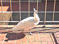
Adult white peahen, New Fortune Theatre
-

St George's College


See also[edit]
- List of universities in Australia
- List of official openings by Elizabeth II in Australia
- Rural Clinical School of Western Australia
- UWA Telerobot
References[edit]
- ^ "Finance 2013" (PDF). Department of Education (Australia). p. 20 (fol. 14).
- ^ "University of Western Australia Act 1911". governance.uwa.edu.au. 2008-03-12. Retrieved 2011-01-22.
- ^ "UWA student wins 100th Rhodes Scholarship". news.uwa.edu.au. 2014-10-31. Retrieved 2014-11-01.
- ^ A University for Western Australia The West Australian, 15 September 1910, at Trove
- ^ Twenty Years History: Genesis of the University The West Australian, 13 April 1932, at Trove
- ^ The University (Letter to the Editor) The West Australian, 2 December 1921, at Trove
- ^ "The University of Western Australia Centenary celebrations".
- ^ "High Degree Awarded.". Kalgoorlie Miner (WA : 1895 - 1950). WA: National Library of Australia. 18 October 1950. p. 5. Retrieved 28 October 2013.
- ^ "Current projects". Retrieved 2017-05-22.
- ^ "Completed projects". Retrieved 2017-05-22.
- ^ "Winthrop Hall". Retrieved 2014-04-11.
- ^ "University Theatres: New Fortune Theatre". theatres.uwa.edu.au. Retrieved 2014-01-20.
- ^ "Graduate Dramatic Society: Past Productions".
- ^ University Dramatic Society Archived 14 April 2011 at the Wayback Machine.
- ^ "The Arts Peacocks". 21 February 2011. Retrieved 21 February 2011.
- ^ "Berndt Museum of Anthropology". Collections Australia Network (archived). Archived from the original on 11 February 2014. Retrieved 6 January 2015.
- ^ Prof. Ted Snell. Berndt Museum News No. 15, June 2014, ISSN 1329-3117, p.9
- ^ http://www.library.uwa.edu.au/library_services/the_subject_libraries__and__scholars_centre
- ^ "Campus Planning Review 2000". cm.uwa.edu.au. Retrieved 2011-01-22.
- ^ "Bachelor of Philosophy (Honours)". studyat.uwa.edu.au. 2014-12-16. Retrieved 2014-12-16.
- ^ "Assured entry to professional courses for school leavers". studyat.uwa.edu.au. 2014-12-16. Retrieved 2014-12-16.
- ^ "UniStats 2013". planning.uwa.edu.au. Retrieved 2014-06-01.
- ^ "UWA wins big share of national research funding". news.uwa.edu. 2012-11-06.
- ^ "Research Institutes and Centres at UWA". 2014-06-17. Retrieved 2014-06-22.
- ^ "UWA to house international radio astronomy research centre". news.uwa.edu.au. 2008-12-15. Retrieved 2011-01-22.
- ^ a b "QS World University Rankings 2016/17". Quacquarelli Symonds Limited.
- ^ "World University Rankings 2016-2017". TSL Education Limited.
- ^ "Academic Ranking of World Universities 2016". Shanghai Ranking Consultancy.
- ^ "U.S. News and World Report Best Global Universities Rankings 2016". U.S. News and World Report.
- ^ a b "CWTS Leiden Ranking 2016". Centre for Science and Technology Studies, Leiden University.
- ^ "THE 2016-2017 - Australia". Times Higher Education.
- ^ "Academic Ranking of World Universities 2016 - Australia". Shanghai Ranking Consultancy.
- ^ "U.S. News and World Report Best Global Universities in Australia/New Zealand". U.S. News and World Report.
- ^ "All unis winners in research audit". The Australian. 4 December 2015. Retrieved 21 February 2017.
- ^ "Australian University Rankings". Australian Education Network.
- ^ "Academic Ranking of World Universities in Clinical Medicine and Pharmacy - 2013". Academic Rankings of World Universities.
- ^ "Academic Ranking of World Universities in Life and Agriculture sciences". Academic Rankings of World Universities.
- ^ "UWA Student Guild Future Directions" (PDF). 2012.
- ^ "Affiliated Clubs and Societies". UWA Student Guild. Retrieved 2014-06-07.
- ^ "Welcome to Uni Camp For Kids". Uni Camp For Kids. Retrieved 2014-06-07.
- ^ Media Statement - New International University Games Launched In Perth
- ^ "2010 Australian University Games Draws and Results". Australian University Sport. 2011-02-22.
- ^ "UWA in Second Life blog". Uwainsl.blogspot.com. Retrieved 2011-01-22.
- ^ "Location of UWA in Second Life". Slurl.com. Retrieved 2011-01-22.
- ^ "Evaluating Second Life as a tool for collaborative scientific visualisation". Local.wasp.uwa.edu.au. Retrieved 2011-01-22.
Further reading[edit]
- Special University Number Western Mail, 21 April 1932, at Trove An extensive supplement commemorating the opening of the university's Crawley campus. See pages 3–23, 33-43 and 77 (back cover page)
- Brief history of the early campus
The Hackett Memorial Buildings at The University of Western Australia, by John Melville-Jones, Hesperian Press 2012.
External links[edit]
| Wikimedia Commons has media related to University of Western Australia. |
Coordinates: 31°58′49″S 115°49′7″E / 31.98028°S 115.81861°E