Marree Man
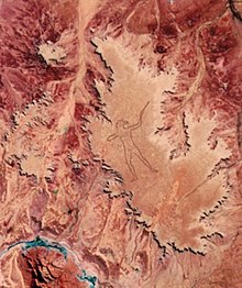
The Marree Man, or Stuart's Giant, is a modern geoglyph discovered by air on 26 June 1998. It appears to depict an indigenous Australian man hunting with a boomerang or stick. It lies on a plateau at Finnis Springs 60 km (36 mi) west of the township of Marree in central South Australia. It is just outside the 127,000 square kilometres (49,000 sq mi)[1] Woomera Prohibited Area. The figure is 4.2 km (2.6 mi) tall with a perimeter of 28 kilometres (17 mi). Although it is the second largest geoglyph in the world (arguably second to the Sajama Lines), its origin remains a mystery, with not a single witness to any part of the expansive operation. The name "Stuart's Giant" was given to it in a fax sent to the media anonymously by those believed to have created the figure, after the explorer John McDouall Stuart.
Shortly after its discovery, the site was closed by the South Australian government following legal action taken in late July by Native Title Claimants but, as of 2010[update], flights were still allowed over the site as Native title falls under federal government jurisdiction.
The site of the Marree Man can be seen in Bing Maps at geo coordinates 29.53 S, 137.46 E.
Contents
Work[edit]
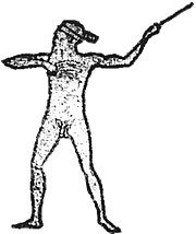
The Marree Man geoglyph depicts a man holding either a Woomera (a throwing stick once used to disperse small flocks of birds) or a boomerang (but see Plaque section below).
The lines of the figure were 20–30 cm (8–12 inches) deep at the time of discovery and up to 35 metres (114 feet) wide. The image was gradually eroded through natural processes, but because the climate is extremely dry and barren in the region, the image was still visible as of 2013[update].[2] While there is a layer of white chalk material slightly below the red soil, the figure was not defined to this depth.
In August 2016, work was carried out to redefine the geoglyph using a grader assisted by GPS. The work resulted in an outline clearly visible from the air, matching the original.[3][4]
Discovery[edit]
Trec Smith, a charter pilot flying between Marree and Coober Pedy in the remote north of South Australia, spotted the figure from the air on 26 June 1998.[5] The discovery of the geoglyph fascinated Australians due to its size and the mystery surrounding how it came to be there.
Shane Anderson from the William Creek Hotel, located 200 km (120 mi) north-west of the town of Marree, claimed the hotel received an anonymous fax describing the location of the artwork, but they ignored it, dismissing the fax as a joke.[citation needed]
Anonymous press releases[edit]
Several anonymous press releases which appeared following the discovery led to the suggestion that the Marree Man was created by people from the United States. The releases said "your State of SA", "Queensland Barrier Reef" and mentioned Aborigines "from the local Indigenous Territories", terms not used by Australians. The press releases also mentioned the Great Serpent in Ohio, which is not well known outside the US. But it has been conjectured that these features of the press releases may have been red herrings, inserted to provide an illusion of American authorship.[citation needed]
When the site was discovered, several items were found in a small pit[citation needed]: what appeared to be a satellite photo of the figure, a jar containing a small flag of the US, and a note which referred to the Branch Davidians, a religious group infamous for being attacked in the Waco raid in 1993.
Plaque[edit]
In January 1999, officials were told about a plaque buried 5 metres (16 feet) south of the nose of the figure. The plaque was an American flag, 3 centimetres (1.2 in) long by 2 centimetres (0.79 in) wide with an imprint of the Olympic rings, reading:
In honour of the land they once knew. His attainments in these pursuits are extraordinary; a constant source of wonderment and admiration.[6]
The quote on the plaque buried at the figure comes from H. H. Finlayson's 1946 book The Red Centre, in a section describing the hunting of wallabies with throwing sticks and with photographs of hunters without loin cloths and other details seen in the "Marree Man".[7] The book deals with hunters of the Pitjantjatjara tribe.[8]
Suggested creator[edit]
Bardius Goldberg, a Northern Territory artist who died in 2002 and lived at Alice Springs, has been suggested as the creator of the work. Goldberg, who was known to be interested in creating a work visible from space, refused to either confirm or deny that he had created the image when questioned. A close friend said Goldberg was given A$10,000 at the time of the Marree Man's discovery.[9]
Reactions[edit]
Much of the public and media reaction to the discovery of the figure was positive. The Advertiser, the state's only daily newspaper, called for the figure to be made permanent by excavating the outline down to the white chalk layer.
At the time of discovery, the area was part of a Federal Court legal battle through the National Native Title Tribunal to determine the "traditional owners". The area was claimed by both the Arabunna people and the Dieri Mitha who had been in dispute for several years.[10] The Dieri Mitha publicly complained of harm and exploitation of the Dreamtime, calling for the image to be erased and for the artist to be prosecuted. As Native Title Claimants, the Dieri Mitha took legal action to stop charter flights and vehicles visiting the site, prompting the state government to close the area to the public shortly after discovery. The Arabunna replied to the issue through a solicitor who stated that the area covered points of archaeological interest and that the artist could be prosecuted.[11] In May 2012, the Federal Court handed native title to the Arabunna people.[12]
The artwork was called environmental vandalism by the former Environment minister, Dorothy Kotz, and graffiti by the South Australian chief of Aboriginal affairs, David Ruthman.[11]
Authenticity of the figure[edit]
There was initially some question as to whether the figure is holding a throwing stick or a boomerang, but these issues seem to have been resolved following discovery of the plaque and the origin of the plaque quote and likely source photographs of similar nude hunters.[7] The hand which is not throwing has the correct posture in the normal Aboriginal technique for throwing.[8] The initiation scars placed on the chest have also been said to have been placed perfectly.[by whom?]
References[edit]
- ^ "WOOMERA PROHIBITED AREA" (PDF). Four Wheel Drive South Australia. 14 April 2002. Retrieved 5 November 2013.
- ^ "Push to spruce up mysterious desert artwork". Australian Broadcasting Corporation. Retrieved 27 May 2013.
- ^ "Marree Man restored as outback tourist attraction". Australian Broadcasting Corporation. 20 August 2016. Retrieved 20 August 2016.
- ^ "Giant Marree Man makes a comeback in South Australian outback". The Guardian. 20 August 2016. Retrieved 21 August 2016.
- ^ "Marree Man". Lake Eyre Helicopters, Contract Helis. Retrieved 30 May 2016.
- ^ "Trash City: News you may have missed". February 1999.
- ^ a b "Marree Man - The Evidence". Archived from the original on 2006-02-26.
- ^ a b "Marree Man - Australia 1998". Archived from the original on 2005-02-07.
- ^ Corcoran, Dee (23 August 2002). "Marree man still a mystery". Northern Territory News. News Limited. Retrieved 31 July 2009.
- ^ In January 1995 the two groups had fought over the issue, leaving one dead and ten injured. In May 1998, only one month before the discovery of the geoglyph, the National Native Title Tribunal took the issue to the Federal Court. Although a resolution was expected to be reached quickly, the case was eventually to take 14 years before the Federal Court was able make a ruling: Dodd v State of South Australia [2012] FCA 519 (22 May 2012), Federal Court (Australia).
- ^ a b Leave our land alone Archived 17 April 2012 at the Wayback Machine. The Advertiser 17 July 1998 State Library of South Australia
- ^ Court ruling on Eyre handover The Australian 22 May 2012
External links[edit]
Coordinates: 29°31′48″S 137°27′56″E / 29.53°S 137.4655°E
- View in Google Maps: "Google Maps". Maps.google.com. Retrieved 2010-09-19.
- Audio Interviews with Brad Thompson, Marree-based pilot: Centenary of Federation - Connecting the Continent
- UFO Updates: Skywatch: New Clues To Marree Man Mystery at the Wayback Machine (archived 15 September 2007)


