Swan Bells

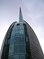
The Swan Bells are a set of 18 bells hanging in a specially built 82.5 metres (271 ft)-high copper and glass campanile in Perth, Western Australia. The tower is commonly known as The Bell Tower or the Swan Bell Tower.[1][2]
Taking their name from the Swan River, which their tower overlooks, and forming a sixteen-bell peal with two extra chromatic notes, they are one of the largest sets of change ringing bells in the world.
Twelve of the set are historic bells from St Martin-in-the-Fields church in Trafalgar Square in London; six others, cast in recent times by the Whitechapel Bell Foundry, round off the set. The St Martin-in-the-Fields bells were donated to the State of Western Australia as part of the 1988 Australian bicentenary celebrations; the additional bells were cast with a subsequent donation of metals mined in Western Australia. The six newer bells include five that were presented to the University of Western Australia, the City of Perth and to the people of Western Australia by the City of London, the City of Westminster and a consortium of British and Australian mining companies, and one bell commissioned by the Western Australian Government.
An inlaid path made of ceramic tiles surrounds the tower. These come from nearly every school in Western Australia and are arranged alphabetically by school name. Each school's tile lists students at that school in the year 1999. As of March 2014[update], the tiles were being removed as part of the Elizabeth Quay project.[3][4]
Contents
History of the St Martin-in-the-Fields bells[edit]
The St Martin-in-the-Fields bells can be traced to before the 14th century. They were recast in the 16th century by order of Queen Elizabeth I and again between 1725 and 1770 by members of the Rudhall family of bell founders from Gloucester.[5] Due to be recast leading up to 1988, instead they were tuned and restored at London's Whitechapel Bell Foundry and donated to Western Australia, on the initiative of local bellringer and businessman Laith Reynolds. They are rare in that they are one of the few sets of royal bells, and more so since they are the only set known to have left England. The bells are also known to have rung as the explorer James Cook set sail on the voyage that founded Australia.
| Bell specifications | |||
|---|---|---|---|
| Bell number | Weight (kg) |
Note | Casting date |
| Treble | 241 | D# | 1998 |
| 2 | 238 | C# | 1988 |
| 3 | 263 | B# | 1988 |
| Flat 3 | 261 | B | 1988 |
| 4 | 254 | A# | 1988 |
| 5 | 279 | G# | 1758 |
| 6 | 263 | F# | 1770 |
| 7 | 284 | E# | 1758 |
| 8 | 300 | D# | 1725 |
| 9 | 370 | C# | 1725 |
| 10 | 390 | B# | 1725 |
| Flat 10 | 453 | B | 1988 |
| 11 | 486 | A# | 1725 |
| 12 | 589 | G# | 1725 |
| 13 | 728 | F# | 1725 |
| 14 | 831 | E# | 1725 |
| 15 | 1,088 | D# | 1726 |
| Tenor | 1,480 | C# | 1726 |
The bell tower[edit]

The tower was designed by the local architects Hames Sharley. The 18 bells have a combined weight of about nine tonnes and, when rung, exert considerable forces on the support structure. To achieve the required stiffness, the six-story bell chamber was made with reinforced concrete cast in situ. The bell chamber was designed by the structural engineering firm Arup.
Soundproof louvres and doors are used to muffle the sound or direct the noise towards the city or the river as required.
The glass-clad spire is designed using spokes which radiate horizontally from a centrally positioned axle, declining in width as it rises to a point. The solid-steel columns of the spire are rectangular and the concrete bell chamber is enveloped in 30 metres (98 ft)-high copper sails and glass.
The redeveloped Barrack Square along Barrack Street precinct, which surrounds the tower, includes reflection pools as well as cafes, restaurants, shops and cycling and walking paths.
Controversy[edit]
The A$5.5 million building was said to be built to commemorate the new millennium, but at the time the government and the then Premier of Western Australia, Richard Court, received a fair amount of criticism from locals who opposed it, calling it a wasteful expenditure. However, it remains one of the only "icon" millennium projects that came in on time, on budget and is still open.[citation needed].
Image gallery[edit]
-

The tower as seen from Barrack Street at dusk
-

-
-

-

-

-
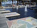
Fountains in front of Swan Bells
-

Sunset from Supreme Court Gardens

.jpg)

.jpg)
.jpg)
.jpg)


See also[edit]
References[edit]
- ^ "The Bell Tower". Western Australian Tourism Commission. Retrieved 1 January 2015.
- ^ Swan Bell Tower – www.LookAtWA.com.au. Retrieved 11 October 2011.
- ^ Ken Acott (28 March 2014). "Bell tolls for quay signatures". The West Australian. Retrieved 29 March 2014.
- ^ "Signatures a thing of the past". Mandurah Mail. 28 March 2014. Retrieved 29 March 2014.
- ^ Perth, The Bell Tower (Swan Bells), Dove's Guide for Church Bell Ringers. Retrieved 2008-07-17
External links[edit]
- Official Swan Bells website
- The Bell Tower at the Department of Culture and the Arts
- The Swan Bells - Perth, Australia, at http://archiloverz.org/
Coordinates: 31°57′32″S 115°51′29″E / 31.95889°S 115.85806°E
| Background and terminology |
 |
|
|---|---|---|
| Bell founders and foundries |
||
| Types | ||
| Bellringing | ||
| Notable bells | ||
| Related | ||