Jefferson National Expansion Memorial
From Wikipedia, the free encyclopedia
| Jefferson National Expansion Memorial | |
|---|---|
| IUCN Category V (Protected Landscape/Seascape) | |
 |
|
| Location | St. Louis, Missouri, USA |
| Coordinates | |
| Area | 192.83 acres (90.96 federal) 0.78 km² |
| Established | December 21, 1965 |
| Total visitation | 2,944,976 (in 2005) |
| Governing body | National Park Service |
The Jefferson National Expansion Memorial (also known as the Gateway Arch or simply The Arch) is located in St. Louis, Missouri near the starting point of the Lewis and Clark Expedition. It was designated as a National Memorial by Executive Order 7523, on December 21, 1965, and is maintained by the National Park Service (NPS).
The park was established to commemorate several historical events:
- the Louisiana Purchase, and the subsequent westward movement of American explorers and pioneers;
- the first civil government west of the Mississippi River;
- the debate over slavery raised by the Dred Scott case.
The memorial site consists of a 91-acre (37 ha) park along the Mississippi River on the site of the original city of St. Louis; the Old Courthouse, a former state and federal courthouse which saw the origins of the Dred Scott case; the 4,200 m² (45,000-sq.ft.) Museum of Westward Expansion; and the Gateway Arch, an inverted steel catenary arch that has become the definitive icon of the city.
As the park entered the 21st century it is host to four million visitors each year, three quarters of whom enter the Arch or the Old Courthouse.
Contents |
[edit] The Gateway Arch


The Arch is known as the "Gateway to the West". Designed by Finnish-American architect Eero Saarinen and structural engineer Hannskarl Bandel, it stands 630 feet (192 m) tall, and is 630 feet (192 m) wide at its base. It is the tallest habitable structure in St. Louis (taller than One Metropolitan Square, the tallest building), and the second tallest in Missouri (behind One Kansas City Place in Kansas City).
The cross-sections of its legs are equilateral triangles, narrowing from 54 feet (16.5 m) per side at the base to 17 feet (5.2 m) at the top. Each wall consists of a stainless steel skin covering reinforced concrete from ground level to 300 feet (91 m) or carbon steel and rebar from 300 feet (91 m) to the peak. The interior of the Arch is hollow and contains a unique transport system leading to an observation deck at the top. The interior of the Arch also contains two emergency stairwells of 1076 steps each, in the event of a need to evacuate the Arch or if a problem develops with the tram system.
[edit] Visitor center

Underneath the Arch is a visitor center, entered from a descending outdoor ramp starting at either base. Within the center is the Museum of Westward Expansion, exhibits on the history of the St. Louis riverfront, and tram loading and unloading areas. Tucker Theater, finished in 1968 and renovated 30 years later, has about 285 seats and shows a documentary (Monument to the Dream) on the Arch's construction. Odyssey Theater was completed in 1993 and has 255 seats. It was the first 70 mm film theater to be located on National Park Service grounds and operated by the NPS. It runs films from a rotating play list. Also located in the visitor center are retail operations run by the Jefferson National Parks Association, a not-for-profit partner.
[edit] Security
Visitors pass through security checkpoints at each entrance to the Arch, before being allowed access to the visitor center. Security was increased as result of a 1997 Congressional mandate to establish a Counter-Terrorism Program at the park. The NPS used the increased funding to purchase magnetometers and x-ray equipment for visitor screening and 25 CCTV cameras scattered throughout the grounds of the memorial.
[edit] Tram
Eero Saarinen died from a brain tumor four years before the Arch was completed; prior to his death he had decided to incorporate a power lift system to obviate the need to climb the 1000-plus stairs. But the shape of the arch would have made a standard elevator impossible. After approaching several elevator companies who failed to come up with a viable method, Saarinen hired college dropout and parking-lot elevator designer Richard Bowser to do the job. Skeptical city leaders gave Bowser only two weeks to submit a design, but he succeeded. By 1968 a unique tram system that combined an elevator cable lift system with gimbaled cars functionally similar to ferris wheel gondolas had been installed.
The tram is operated by the quasi-governmental Bi-State Development Agency under an agreement with the NPS.
From the visitor center one may move to either base (one on the north end and the other on the south end) of the Arch and enter the tramway much as one would enter an ordinary elevator, through narrow double doors. The north queue area includes displays which interpret the design and construction of the Gateway Arch; the south queue area includes displays about the St. Louis riverfront during the mid-19th century.
Passing through the doors, passengers in groups of five enter an egg-shaped compartment containing five seats and a flat floor. Because of the car shape, the compartments have sloped ceilings low enough to force taller riders to lean forward while seated (for this reason it's recommended that the tallest of the five passengers in the car sit in the center seat facing the door). Eight compartments are linked to form a train, meaning that both trains have a capacity of 40, and that 80 people can be transported at one time. These compartments individually retain an appropriate level by periodically rotating every 5 degrees, which allows them to maintain the correct orientation while the entire train follows curved tracks up one leg of the arch. The trip to the top of the Arch takes four minutes, and the trip back down takes three minutes. The car doors have narrow glass panes, allowing passengers to see the interior stairways and structure of the Arch during the trip.
On July 21, 2007, several hundred people were trapped in the trams or at the top of the Arch after an electrical problem occurred with the tram system. All were returned to the ground either by taken down stairs to a service elevator, or by waiting for power to be restored. A second electrical problem caused one tram to be taken out of service the following day.
[edit] Observation area
Near the top of the arch, the rider exits the compartment and climbs a slight grade to enter the arched observation area. Small windows, almost invisible from the ground, allow views across the Mississippi River and southern Illinois with its prominent Mississippian culture mounds to the east at Cahokia, and the City of Saint Louis and St. Louis County to the west beyond the city. On a clear day, one can see up to thirty miles. (48 km)
[edit] History
In 1947, a group of civic leaders held a national competition to select a design for the main portion of the Memorial space. Eero Saarinen won this competition with plans for a 590-foot (180-metre) catenary arch to be placed on the banks of the Mississippi River. However, these plans were modified over the next 15 years, placing the arch on higher ground and adding 40 feet (12 m) in height and width.
Saarinen developed the shape with the help of architectural engineer Hannskarl Bandel. It is not a pure inverted catenary. Saarinen preferred a shape that was slightly elongated and thinner towards the top, a shape that produces a subtle soaring effect, and transfers more of the structure's weight downward rather than outward at the base.
When Saarinen won the competition, the official notification was sent to "E. Saarinen", thinking it to be the architect's father Eliel Saarinen, who had also submitted an entry. The family celebrated with a bottle of champagne, and two hours later an embarrassed official called to say the winner was, in fact, the younger Saarinen. The elder Saarinen then broke out a second bottle of champagne to celebrate his son's success.
The construction of the Arch began February 12, 1963 and was completed on October 28, 1965, costing approximately US$15 million to build. Along with all other historical areas of the National Park Service, the memorial was listed on the National Register of Historic Places on October 15, 1966. Vice President Hubert Humphrey and Secretary of the Interior Stewart Udall dedicated the Arch on May 25, 1968.
In 1984, Congress authorized the enlargement of the Memorial to include up to 100 acres on the east bank of the Mississippi River in East St. Louis, Illinois. Funds were authorized to begin land acquisition, but Congress placed a moratorium upon NPS land acquisitions in fiscal year 1998. The moratorium continued into the 21st century, with expansion becoming less likely because of the construction of a riverboat gambling facility and related amenities.
In 1999, the Arch tram queue areas were completely renovated at a cost of approximately $2.2 million.
[edit] Mathematics of the Arch
The geometric form of the Arch was set by mathematical equations provided to Saarinen by Dr. Hannskarl Bandel. Bruce Detmers and other architects expressed the geometric form in blueprints with this equation:

or, equivalently

where

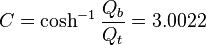
- fc = maximum height of centroid (in feet) = 625.0925
- Qb = maximum cross sectional area of arch at base (in sq. feet) = 1262.6651
- Qt = minimum cross sectional area of arch at top (in sq. feet) = 125.1406
- L = half width of centroid at the base (in feet) = 299.2239
This hyperbolic cosine function describes the shape of a catenary. A chain that supports only its own weight forms a catenary; in this configuration, the chain is strictly in tension. An inverted catenary arch that supports only its own weight is strictly in compression, with no shear. The shape is therefore ideal.
The base of each leg at ground level had an engineering tolerance of one sixty-fourth of an inch or the two legs would not mate at the top.
[edit] Stunts
No fewer than eleven light aircraft have been successfully piloted beneath the arch, the first on 22 June 1966, when the arch had been completed for less than a year.[1]
In 1980 Kenneth Swyers tried to parachute onto the span of the Gateway Arch, planning to jump back off to land on the ground below. Instead, he slid all the way down one leg to his death. The pilot, Richard Skurat, had his pilot certificate suspended for 90 days.[2]
In 1984, David Adcock of Houston, Texas, began to scale the arch by means of suction cups on his hands and feet, but he was talked out of continuing after having climbed only 20 feet. The next day he successfully scaled the nearby 21-story Equitable Building in downtown St. Louis.
On 14 September 1992 it was rumored that John C. Vincent of New Orleans successfully scaled the outside of the Arch with suction cups during the night, and performed a BASE jump from the top with a parachute at 7 a.m. No evidence surfaced to support his claim, and it was speculated by Rangers at the Arch that Vincent was lowered from a helicopter onto the top of the Arch, from which he parachuted off. He spent three months in jail for the stunt.[3]
[edit] External links
- Official NPS website: Jefferson National Expansion Memorial
- The memorial's 2000-2005 Strategic Plan (in Microsoft Word format)
- Commemorative Events at Jefferson National Expansion Memorial for the 150th Anniversary of the Dred Scott Decision
- Website for “The Gateway Arch: A Reflection of America”, a documentary narrated by Kevin Kline and directed by award winning documentarians Scott Huegerich and Bob Miano of Civil Pictures.
- Gateway Arch tourism site, run by the Bi-State Development Agency
- Jefferson National Parks Association, a park partner which administers the Museum Store and the Levee Mercantile Store
- Gateway Arch Photographs in the Western Historical Manuscript Collection at the University of Missouri-St. Louis
- 3D model of the Gateway Arch for use in Google Earth
- A SketchUp model of the Gateway Arch that can be viewed in Google Earth or Google SketchUp.
- St. Louis math teacher William V. Thayer's web pages on arch mathematics[4][5]
- Web page for the equations of the Arch on the official website of the Jefferson National Expansion Memorial[6]
- 1980 Darwin Award
- The National Parks: Index 2001–2003. Washington: U.S. Department of the Interior.
- Arch timeline from the St. Louis Post-Dispatch
- Gateway Arch live webcam
[edit] Additional photographs
 The Arch, through a clearing amongst the trees, July 2006 |
 |
 |
 The Arch, from the south |
 The observation deck as seen from the riverfront area |
 The Arch, from near the Old Cathedral |
 The Arch, reflected in the North Basin |
 The Arch, reflected in the North Basin |
 The Arch, from the west |
 The sign at the top of the observation deck. |
 The St. Louis Arch as seen from the lawn. |
 The Gateway Geyser with the Gateway Arch |
 Airshow at the Arch |
 The Old Courthouse |
 View of Old Busch Stadium from the Observation deck. |
 Another view of the Gateway Arch as seen from the lawn. |
 A view of the current Busch Stadium as seen from the Gateway Arch's observation deck |
 The arch seen behind Busch Stadium |
 As seen from Laclede's Landing |
 Old Courthouse as viewed from top of Gateway Arch |
 Arch at night |
 Fireworks by the Arch |
 Arch at dawn |
 As viewed from roof of the Adam's Mark Hotel |
 Old Basilica as viewed from top of Arch |
 As viewed driving east on Market Street |
 As viewed from inside Old Basilica |
 As viewed from west of Old Basilica |
 As viewed from west of Old Courthouse |
 North Tram entrance in March 2005. |
 Looking up at the Arch |
Categories: IUCN Category V | 1965 establishments | 1965 architecture | Buildings and monuments honoring American Presidents | Buildings and structures in St. Louis | Eero Saarinen structures | Lewis and Clark Expedition | Landmarks in Missouri | National Memorials of the United States | Parks in St. Louis | Parks on the Mississippi River | Registered Historic Places in Missouri | Thomas Jefferson | Modernist architecture | American architecture

