Puerto Madryn
|
|
This article may be expanded with text translated from the corresponding article in Spanish. (February 2011) Click [show] for important translation instructions.
|
| Puerto Madryn | |||
|---|---|---|---|
| City | |||
 |
|||
|
|||

Puerto Madryn
|
|||
| Coordinates: 42°46′S 65°3′W / 42.767°S 65.050°WCoordinates: 42°46′S 65°3′W / 42.767°S 65.050°W | |||
| Country | Argentina | ||
| Province | Chubut | ||
| Department | Viedma | ||
| Founded | 28 July 1865 | ||
| Founded by | Love Jones Parry | ||
| Government | |||
| • Mayor | Ricardo Sastre (Justicialist Party) | ||
| Area | |||
| • Total | 330 km2 (130 sq mi) | ||
| Elevation | 17 m (56 ft) | ||
| Population (2012) | |||
| • Total | 73,612 | ||
| • Density | 220/km2 (580/sq mi) | ||
| Demonym(s) | madrynense | ||
| Time zone | ART (UTC-3) | ||
| CPA base | U9120 | ||
| Dialing code | +54 2804 | ||
| Climate | BWk | ||
| Website | Official website | ||


Puerto Madryn (Spanish pronunciation: [ˈpweɾto ˈmaðɾin]) is a city in the province of Chubut in Argentine Patagonia. It is the capital of the Biedma Department, and has about 93.995 inhabitants according to the last census in 2010.
Puerto Madryn is protected by the Golfo Nuevo, which is formed by the Península Valdés and the Punta Ninfas. It is an important centre for tourists visiting the natural attractions of the Península Valdés and the coast.
A new shopping mall in the city centre has helped tourism significantly, making Puerto Madryn a more attractive place for both international and domestic tourists visiting Patagonia. It is twinned with Nefyn, a small town on the Llŷn Peninsula in North Wales, the result of its enduring link with Welsh culture since the Welsh settlement in Argentina. The first of a two-Test tour to Argentina by the Wales national rugby union team was played in 2006 in Puerto Madryn, a 27–25 win for Argentina. Puerto Madryn is home to two football clubs; Club Social y Atlético Guillermo Brown, who play in Nacional B and Deportivo Madryn that currently play in Torneo Argentino B.
A basketball team, Deportivo Puerto Madryn, plays in the Liga Nacional de Básquetbol (LNB). Their home arena is known as the Deportivo Puerto Madryn Arena.
El Tehuelche Airport is located 10 km northwest of the city centre. Commercial flights from Buenos Aires, Ushuaia, and other Argentinian cities are available. Most tourists fly into Trelew Airport as flights into Puerto Madryn are restricted as a result of environmental concerns.
Geography and climate[edit]
Puerto Madryn is situated in Chubut on the Golfo Nuevo, which is formed by the Valdés Peninsula and Punta Ninfas. The climate is that of a temperate desert zone, with an annual precipitation of between 150 and 200 mm.
| Climate data for Puerto Madryn | |||||||||||||
|---|---|---|---|---|---|---|---|---|---|---|---|---|---|
| Month | Jan | Feb | Mar | Apr | May | Jun | Jul | Aug | Sep | Oct | Nov | Dec | Year |
| Record high °C (°F) | 39.7 (103.5) |
39.0 (102.2) |
37.5 (99.5) |
34.9 (94.8) |
27.7 (81.9) |
24.5 (76.1) |
24.5 (76.1) |
29.0 (84.2) |
30.2 (86.4) |
34.9 (94.8) |
36.2 (97.2) |
39.0 (102.2) |
39.7 (103.5) |
| Average high °C (°F) | 27.4 (81.3) |
26.9 (80.4) |
24.4 (75.9) |
20.8 (69.4) |
16.1 (61) |
12.9 (55.2) |
12.8 (55) |
14.5 (58.1) |
17.0 (62.6) |
19.9 (67.8) |
23.7 (74.7) |
26.2 (79.2) |
20.2 (68.4) |
| Daily mean °C (°F) | 19.9 (67.8) |
19.4 (66.9) |
17.3 (63.1) |
14.2 (57.6) |
10.4 (50.7) |
7.8 (46) |
7.3 (45.1) |
8.5 (47.3) |
10.5 (50.9) |
13.1 (55.6) |
16.0 (60.8) |
18.3 (64.9) |
13.6 (56.5) |
| Average low °C (°F) | 13.7 (56.7) |
13.2 (55.8) |
11.1 (52) |
8.1 (46.6) |
5.1 (41.2) |
3.0 (37.4) |
2.1 (35.8) |
2.7 (36.9) |
4.5 (40.1) |
6.9 (44.4) |
9.7 (49.5) |
12.0 (53.6) |
7.7 (45.9) |
| Record low °C (°F) | 3.8 (38.8) |
1.7 (35.1) |
−2.0 (28.4) |
−4.8 (23.4) |
−5.7 (21.7) |
−9.6 (14.7) |
−11.6 (11.1) |
−10.0 (14) |
−6.0 (21.2) |
−5.9 (21.4) |
−2.0 (28.4) |
2.2 (36) |
−11.6 (11.1) |
| Average precipitation mm (inches) | 10.0 (0.394) |
14.1 (0.555) |
16.6 (0.654) |
12.6 (0.496) |
23.8 (0.937) |
14.1 (0.555) |
16.6 (0.654) |
10.6 (0.417) |
14.1 (0.555) |
17.8 (0.701) |
10.1 (0.398) |
12.4 (0.488) |
172.8 (6.803) |
| Average relative humidity (%) | 49 | 53 | 54 | 56 | 63 | 66 | 63 | 59 | 58 | 59 | 51 | 48 | 57 |
| Source: Secretaria de Mineria[1] | |||||||||||||
History[edit]
The town was founded on 28 July 1865, when 150 Welsh immigrants arriving aboard the clipper Mimosa named the natural port Porth Madryn in honour of Sir Love Jones-Parry, whose estate in Wales was named "Madryn". The settlement grew as a result of the building of the Central Chubut Railway by Welsh, Spanish, and Italian immigrants. This line, opened in 1889, linked the town to Trelew via the lower Chubut River valley.[2]
See also[edit]
Gallery[edit]
-
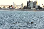
View of Puerto Madryn from the bay.
-
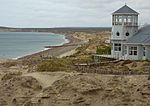
Puerto Madryn coast.
-
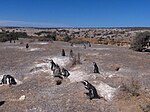
Penguin population near the coast.
-

Flag of Argentina in Puerto Madryn.


.JPG)
References[edit]
- ^ "Provincia de Chubut - Clima Y Meteorologia: Datos Meteorologicos Y Pluviometicos" (in Spanish). Secretaria de Mineria de la Nacion (Argentina). Retrieved April 2013.
- ^ Williams, Glyn (1975). The desert and the dream: A study of Welsh colonization in Chubut 1865 - 1915. Cardiff: University of Wales Press. p. 82. ISBN 0-7083-0579-2.
External links[edit]
| Wikimedia Commons has media related to Puerto Madryn. |
- Project-Hiraeth – Documents the stories of the Welsh colony in Patagonia, Argentina through film, text and illustration.
- Municipal information: Municipal Affairs Federal Institute (IFAM), Municipal Affairs Secretariat, Ministry of Interior, Argentina. (Spanish)
- Official website