Cerro de la Silla
| Cerro de la Silla | |
|---|---|

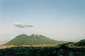
Cerro de la Silla in 2004
|
|
| Elevation | 1,820 m (5,970 ft) |
| Translation | Saddle Hill (Spanish) |
| Pronunciation | Spanish pronunciation: [ˈsero ˌðelaˈsiʝa] |
| Location | |
| Location | Guadalupe and Monterrey, Nuevo León, Mexico |
| Coordinates | 25°37′23″N 100°14′34″W / 25.62306°N 100.24278°WCoordinates: 25°37′23″N 100°14′34″W / 25.62306°N 100.24278°W |
| Climbing | |
| Easiest route | Hike |
The Cerro de la Silla is a mountain and natural monument located within the metropolitan area of the city of Monterrey, Nuevo León, in northeastern Mexico. Named for its distinctive saddle-shaped profile when viewed from the west, it is a well-known symbol of the city of Monterrey, despite being located in the adjacent municipality of Guadalupe.
It covers an area of 60.5 square kilometres (23 mi²). The mountain has four peaks: Pico Antena, Pico Norte, Pico Sur and Pico la Virgen; Pico Norte (North Peak) is the highest at 1820 m (5970 ft) while Pico la Virgen (Virgin's Peak) is the lowest at 1750 m (5740 ft).
Set aside as a natural monument by the Mexican government in 1991, the mountain, or hill, as mountains are often referred to in Mexico, is a popular recreational area and is often climbed by hikers who take a 5.3 km (3.3 mi) trail to reach the top. The ascent is considered to be fairly difficult, taking approximately 3 hours to complete. A panoramic view of the city of Monterrey can be seen from the top.
In the second half of the 20th century, an aerial tramway was built to give a fastest access to the iconic mountain for the population. The day of its inauguration was also the day of its closure, as a tragic accident took the lives of five people, including the engineer Jesús Fernández, its designer. Several plans have been announced to rebuild another tramway with no results.[citation needed]
Some other known mountains or elevations of the zone are: Cerro de las Mitras, the Sierra Madre Oriental with the Cerro de Chipinque —the M-shaped figure visible from various parts of the city—, the Cerro del Topo Chico, Cerro del Obispado, Cerro de la Loma Larga and La Huasteca.
Gallery[edit]
-
Cerro de la Silla as seen from Cerro del Obispado
-

Atop view of Cerro de la Silla.
-

Monterrey view from Cerro de la Silla.


External links[edit]
- Cerro de la Silla information (Spanish)
- Mexico Desconocido (Spanish)