Port River
| Port | |
| Port Adelaide | |
| River | |
 The Port River in relation to Adelaide city centre, the redirected River Torrens, and the adjacent Barker Inlet
|
|
| Country | Australia |
|---|---|
| State | South Australia |
| Region | Western Adelaide |
| Municipality | City of Port Adelaide Enfield |
| Tributaries | |
| - right | North Arm |
| Source | Semaphore Park |
| - coordinates | 34°51′S 138°29′E / 34.85°S 138.49°E |
| Mouth | Gulf St Vincent |
| - location | Outer Harbor |
| - elevation | 0 m (0 ft) |
| - coordinates | 34°47′S 138°28′E / 34.78°S 138.47°ECoordinates: 34°47′S 138°28′E / 34.78°S 138.47°E |
| Bridges |
|

Location of the river mouth in South Australia
|
|
The Port River (officially known as the Port Adelaide River) is a river located north of the Adelaide central business district in the Australian state of South Australia.
Contents
Naming[edit]
The river is officially known as the Port Adelaide River while the name Port River is described in official sources as "a local variant."[1][2]
Course and features[edit]
The Port River is the western branch of the largest tidal estuary on the eastern side of Gulf St Vincent. It extends inland through the historic Inner Harbour of Port Adelaide, to the constructed salt-water West Lakes in the north-western suburbs of Adelaide. The lower reaches of the Port River flow between the Lefevre Peninsula, and the Section Bank and Torrens Island, and form the sea entrance to the port facilities of Adelaide, and connect to the Barker Inlet to the east via the North Arm and Angas Inlet which surround Garden Island. Before European settlement of Adelaide's western suburbs and the construction of various flood mitigation channels and levees, the Port River formed one of the outlets of the River Torrens.
The banks of the river are largely industrialised and have some of Adelaide’s wharves, bulk cargo and container handling facilities, although there are some remnant mangroves. One of its main attractions other than transport is the Port River dolphins, which are the only wild dolphins in the world that live within a city.[3]
Besides shipping using the river’s main channel, a fishing fleet operates out of the North Arm which also has a speed boat club. Recreational boating marinas are located in the Angas Inlet and on the Lefevre Peninsula.. The ASC (formerly the Australian Submarine Corporation) has its construction and maintenance facility and dock at Osborne, and there is a heritage-listed former Quarantine Station on Torrens Island. Several power stations including the Torrens Island Power Station and the Pelican Point Power Station, draw seawater from the Port River for cooling purposes. The Port Adelaide Rowing Club has rowed on the river for one hundred and thirty years,[4] and the river was formerly a frequent venue for the Intervarsity eights race.
Environment[edit]
Prior to European settlement of the Adelaide Plains, winter rains over the catchment of the River Torrens created large seasonal inflows of fresh water into the Reedbeds wetlands, which drained north into the Port River and south to the Patawalonga River. Since construction of the Breakout Creek outlet in the 1930s to drain the Reedbeds, and the closure of the former Port Adelaide Wastewater Treatment Plant with the diversion of wastewater to Bolivar in 2005, the upper reaches of the Port River now receive only limited amounts of locally derived stormwater, and are now largely marine. Flushing of the West Lakes occurs through a one-way system that takes in fresh seawater through an inlet off the coast at the southern end, and discharges into the upper reaches of the Port River.
Despite clearing for industrial purposes since the early days of European settlement, mangrove forests (consisting of only one species, Avicennia marina var resinifera) remain in New Port and along the shores of Torrens Island, the North Arm which connects to Barker Inlet, and north of the ASC facility, adjacent to the Mutton Cove Conservation Reserve on the Lefevre Peninsula. Spring tides are over 2.5 metres (8 ft 2 in) AHD and at low tide mudflats are exposed near the outlet of the river, forming a breeding ground for blue swimmer crabs and other species. The Adelaide Dolphin Sanctuary, a 118-square-kilometre (46 sq mi) Dolphin sanctuary which was enacted by the 2005 Adelaide Dolphin Sanctuary Act covers all of the Barker Inlet and the Port River. Bottlenose dolphins are often seen in the river, examining and following small boats and have become a well known tourist attraction with dolphin cruises departing from Queens Wharf.[5][6] The industrialised nature of the Port River has led to concern for the welfare of the bottlenose dolphin population and studies have shown that some of the dolphins have very high heavy metal burdens in comparison to dolphins elsewhere.[7][8] The mudflats at the mouth of the river are part of the Gulf St Vincent Important Bird Area.[9]
Settlement history[edit]
Prior to the 1836 settlement of South Australia, the river was a shallow and narrow tidal creek winding between mangrove swamps. The river was officially discovered in 1834 by Captain John Jones after an 1831 sighting by Captain Collet Barker.[10] The initial landing place in Adelaide was some way north of the current port and had such poor conditions that for many years it was known as Port Misery.[11] In 1837 a harbour was declared when harbourmaster Captain Thomas Lipson took up residence on the shore of the then named port creek with the first migrants landing in the same year and Mclaren wharf built in 1839.[12] The current port location was opened in 1840 but, due to the shallow depth of the river, a new harbor was authorised for construction at Outer Harbor in 1902 and completed in 1908.[11] This new harbour allowed the larger steamships that were then arriving at Adelaide to dock, with smaller steam vessels and sailboats able to use the old port facilities.
The river was first bridged in 1859 opening the Lefevre Peninsula to development and now is crossed by 3 road bridges including the Birkenhead bridge, the first bascule moving bridge in Australia.
Ships graveyard[edit]
The North Arm contains a significant ships graveyard with 25 identified wrecks and was also used to house explosives stores from the 1880s.[13] The remains of the iron and wooden ships that were abandoned between 1909 and 1945 are now bird roosts and a canoeing attraction.[11][14] The ships in the graveyard were launched from 1857 to 1920 and includes the Dorothy H. Sterling as well as other sailing ships, steamships and iron barges.[11]
Gallery[edit]
-

Aerial view of the Port River estuary
-

Pleasure cruise, merchant ships and industry on the river
-
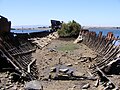
Wreck of the Sunbeam in the graveyard
-

Torrens Island Power Station and transmission lines viewed from North Arm Creek


See also[edit]
References[edit]
- ^ "Search result for "Port Adelaide River (STRM)" (Record no SA0040455) with the following layers being selected - "Suburbs and Localities", "Local Government Areas" and "Place names (gazetteer)"". Property Location Browser. Government of South Australia. Retrieved 2 May 2017.
- ^ "Search result for "Port River (STRM)" (Record no SA0040456) with the following layers being selected - "Suburbs and Localities", "Local Government Areas" and "Place names (gazetteer)"". Property Location Browser. Government of South Australia. Retrieved 2 May 2017.
- ^ "Port River Dolphins, George Negus Tonight". Australian Broadcasting Corporation. 2004-06-07. Retrieved 2007-01-03.
- ^ Messenger Community Newspapers Local News Adelaide South Australia
- ^ "Adelaide Dolphin Sanctuary, Location and Maps". South Australian Department of Environment and Heritage. 2006. Retrieved 2006-12-26.
- ^ "Adelaide Dolphin Sanctuary Act 2005". Retrieved 2006-12-26.
- ^ Lavery, T. J.; Kemper, C. M.; Sanderson, K.; Schultz, C. G.; Coyle, P.; Mitchell, J. G.; Seuront, L. (February 2009). "Heavy metal toxicity of kidney and bone tissues in South Australian adult bottlenose dolphins (Tursiops aduncus)". Marine Environmental Research. 67 (1): 1–7. doi:10.1016/j.marenvres.2008.09.005.
- ^ Lavery, T. J.; Butterfield, N.; Kemper, C. M.; Reid, R. J.; Sanderson, K. (2008). "Metals and selenium in the liver and bone of three dolphin species from South Australia, 1988 - 2004". Science of the Total Environment. 390 (1): 77–85. doi:10.1016/j.scitotenv.2007.09.016.
- ^ BirdLife International. (2011). Important Bird Areas factsheet: Gulf St Vincent. Downloaded from http://www.birdlife.org on 03/07/2011
- ^ "History of Port Adelaide". Port Adelaide Historical Society. Retrieved 2007-01-03.
- ^ a b c d Hartell, Robyn; Richards, Nathan (2001). Garden Island, Ships's Graveyard. Heritage SA, Department for Environment and Heritage. pp. 1–6. ISBN 0-7308-5894-4.
- ^ "Port Adelaide". Flinders Ranges Research, southaustralianhistory.com.au. Retrieved 2006-01-03.
- ^ Richards, Nathan (1997). "The History and Archaeology of the Garden Island Ships' Graveyard, North Arm of the Port River, Port Adelaide, South Australia (Honours thesis, BA(Hons), Archaeology)" (PDF). Flinders University of South Australia. pp. 26–30. Retrieved 2012-06-12.
- ^ "Port Adelaide (Ships' Graveyards)". South Australian Department of Environment and Heritage. Retrieved 2012-06-12.