Berkeley Pit
| Silver Bow Creek/Butte Area | |
|---|---|
| Superfund site | |

Berkeley Pit and Yankee Doodle tailings pond with terraced levels/access roadways (left side of image is roughly north).
|
|
| Geography | |
| City | Butte |
| County | Silver Bow County |
| State | Montana |
| Coordinates | 46°01′02.38″N 112°30′36.60″W / 46.0173278°N 112.5101667°WCoordinates: 46°01′02.38″N 112°30′36.60″W / 46.0173278°N 112.5101667°W |

Silver Bow Creek/Butte Area
Berkeley Pit's location in Montana.
|
|
| Information | |
| CERCLIS ID | MTD980502777 |
| Contaminants | Arsenic, cadmium, copper, zinc, lead |
| Progress | |
| Proposed | 12/30/1982 |
| Listed | 09/08/1983 |
| List of Superfund sites | |
The Berkeley Pit is a former open pit copper mine located in Butte, Montana, United States. It is one mile long by half a mile wide with an approximate depth of 1,780 feet (540 m). It is filled to a depth of about 900 feet (270 m) with water that is heavily acidic (2.5 pH level), about the acidity of cola or lemon juice.[1] As a result, the pit is laden with heavy metals and dangerous chemicals that leach from the rock, including copper, arsenic, cadmium, zinc, and sulfuric acid.[1]
The mine was opened in 1955 and operated by Anaconda Copper and later by the Atlantic Richfield Company (ARCO), until its closure on Earth Day 1982. When the pit was closed, the water pumps in the nearby Kelley Mine, 3,800 feet below the surface, were turned off, and groundwater from the surrounding aquifers began to slowly fill the pit, rising at about the rate of one foot a month.[1] Since the pit closure in 1982, the level has risen to within 150 feet of the natural groundwater level.
The pit and its water present a serious environmental problem because the water, with dissolved oxygen, allows pyrite and sulfide minerals in the ore and wall rocks to decay, releasing acid. When the pit water level eventually reaches the natural water table, estimated to occur by around 2020, the pit water will reverse flow back into surrounding groundwater, polluting into Silver Bow Creek which is the headwaters of Clark Fork River.[1] The acidic water in the pit carries a heavy load of dissolved heavy metals. In fact, the water contains so much dissolved metal (up to 187 ppm Cu) that some material is mined directly from the water.
In the 1990s plans were devised for solving the groundwater problem. Water flowing into the pit has been diverted to slow the rise of the water level. Plans have been made for more extensive treatment in the future. The Berkeley Pit has since become one of the largest Superfund sites.
The pit is currently a tourist attraction, with an adjacent gift shop. A $2 admission fee is charged to go out on the viewing platform.
Contents
Early history and development[edit]

The underground Berkeley Mine was located on a prominent vein extending to the southeast from the main Anaconda vein system. When open pit mining operations began in July 1955, near the Berkeley Mine shaft, the older mine gave its name to the pit. The open-pit style of mining superseded underground operations because it was far more economical and much less dangerous than underground mining.
Within the first year of operation, the pit extracted 17,000 tons of ore per day at a grade of 0.75% copper. Ultimately, about 1,000,000,000 tons of material were mined from the Berkeley Pit. Copper was the principal metal produced, although other metals were also extracted, including silver and gold.[2]
Two communities and much of Butte's previously crowded east side were consumed by land purchases to expand the pit. The Anaconda Company bought the homes, businesses and schools of the working-class communities of Meaderville, East Butte, and McQueen, east of the pit site. Many of these homes were either destroyed, buried, or moved to the southern end of Butte. Residents were compensated at market value for their lost property.
Geology[edit]
Mining of sulfide minerals began in the Butte mining district in 1864. Placer deposits were mined out by 1867. Silver vein lodes were then the most productive until copper was discovered in 1888. Open-pit mining started in 1955. Copper has historically been the main metal produced, though lead, zinc, manganese, silver and gold have been produced at various times.[3]
The district is characterized by the Late Cretaceous Boulder batholith which metamorphosed surrounding rocks during the Laramide orogeny. Ore formation occurred with the intrusion of the Butte quartz monzonite pluton.[3]
-

Geologic Cross Section
-
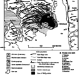
Butte District Geologic map
-

Mineral Zones


Environmental effects[edit]


In 1995, a flock of migrating geese landed in the Berkeley Pit water and died. A total of 342 carcasses were recovered.[4] ARCO, the custodian of the pit, denied that the toxic water caused the death of the geese, attributing the deaths to an acute aspergillosis infection that may have been caused by a grain fungus, as substantiated by Colorado State University necropsy findings. These findings were disputed by the State of Montana on the basis of its own lab tests.[4] Necropsies showed their insides were lined with burns and festering sores from exposure to high concentrations of copper, cadmium, and arsenic.[1]
On November 28, 2016 several thousand snow geese died after a large flock landed in the pit's water to avoid a snow storm.[5] Although an official count is incomplete as of early December 2016, the total is expected to be many times greater than the earlier 1995 incident. Immediately after the event, officials made efforts to scare birds away and prevent more from landing in the area.
The most recent development in the clean-up was the construction of a treatment plant on Horseshoe Bend. This facility treats and diverts water coming from the Horseshoe Bend flow. In addition, it will be able to treat the existing Berkeley Pit water in 2018, or whenever the water level hits the critical point of 5,410 feet (1,650 m) above sea level. This number was set by federal order and is intended to protect the ground water from being contaminated by the water in the pit.
The Berkeley Pit is on the federal Superfund site list.[6]
Extremophiles[edit]
A protozoan species—Euglena mutabilis—was found to reside in the pit by Andrea A. Stierle, and Donald B. Stierle, and they have been found to have adapted to the harsh conditions of the water.[1] Intense competition for the limited resources caused these species to evolve the production of highly toxic compounds to improve survivability; natural products such as Berkeleydione, berkeleytrione [7] and Berkelic acid [8] have been isolated from these organisms which show selective activity against cancer cell lines. Some of these species ingest metals and are being investigated as an alternative means of cleaning the water.[1]
Important dates[edit]
- 1994 – September, EPA/DEQ issue Record of Decision (ROD) for Butte Mine Flooding Operable Unit.
- 1996 – April, Montana Resources (MR) and ARCO divert Horseshoe Bend (HSB) drainage water away from Berkeley Pit to slow filling rate, per ROD.
- 2000 – July, MR suspends mining operations due to high energy costs; HSB water allowed to flow back into pit, increasing pit filling rate.
- 2002 – March, USEPA and Montana Department of Environmental Quality (MDEQ) enter into a Consent Decree with BP/ARCO and the Montana Resources Group (known as the Settling Defendants) for settlement of past and future costs for this site.
- 2002 – Fall, USEPA and MDEQ issue order for Settling Defendants to begin design of water treatment plant for HSB water. Settling Defendants issue contract and begin construction of treatment plant.
- 2003 – November, MR resumes mining operations.
- 2003 – November 17, HSB water treatment plant comes on line slowing pit filling rate.
Geography[edit]
The mine is at 46°00′56″N 112°30′37″W / 46.01556°N 112.51028°W, at an altitude of 4698 feet (1432 m) above mean sea level.
See also[edit]
References[edit]
- ^ a b c d e f g Edwin Dobb. "New Life in a Death Trap". Discover, 2000
- ^ "Berkeley Pit History". Colorado State University, Department of Biology. Archived from the original on 2009-04-28. Retrieved 2009-02-21.
- ^ a b Edwin W. Tooker (1990). Gold in the Butte District, Montana in USGS Bulletin 1857 Gold in Copper Porphyry Copper Systems. United States Government Printing Office. p. E17-E27.
- ^ a b Adams, Duncan (1995-12-11). "Did toxic stew cook the goose?". High County News. Retrieved 2006-05-07.
- ^ "Thousands of snow geese die in Montana after landing on contaminated water". The Guardian. Associated Press. 6 December 2016. Retrieved 7 December 2016.
- ^ "NASA - Berkeley Pit: Butte, Montana". www.nasa.gov. Retrieved 2009-10-09.
- ^ "Berkeleydione and Berkeleytrione, New Bioactive Metabolites from an Acid Mine Organism". Organic Letters. 6: 1049–1052. doi:10.1021/ol049852k.
- ^ "Berkelic Acid, A Novel Spiroketal with Selective Anticancer Activity from an Acid Mine Waste Fungal Extremophile". The Journal of Organic Chemistry. 71: 5357–5360. doi:10.1021/jo060018d.
- Notes
- McClave, M. A. (1973). Control and distribution of supergene enrichment in the Berkeley Pit. in Guidebook. Butte District, Montana: Butte Field Meeting of Society of Economic Geologists. pp. K–1–K–4.
- Shovers, B.; Fiege, M.; Martin, D.; Quivik, F. (1991). Butte and Anaconda revisited. Special Pub. 99. Montana: Montana Bureau of Mines and Geology.
- Weed, W. H. (1912). Geology and ore deposits of the Butte District. Professional Paper 74. Montana: U.S. Geological Survey.
Further reading[edit]
- Leech, Brian. "Boom, Bust, and the Berkeley Pit: How Insiders and Outsiders Viewed the Mining Landscape of Butte, Montana". IA, The Journal of the Society for Industrial Archeology. 37 (1-2): 153–170. JSTOR 23757914.
External links[edit]
- Berkeley Pit Photos from the Montana Department of Environmental Quality
- PitWatch
- ISS image of Berkeley Pit (dated August 2, 2006)
- Researchers Hope Creatures From Black Lagoon Can Help Fight Cancer - Wired News
- Berkeley Pit on Google Maps
- Butte, Montana toxic waste site turned tourist attraction yielding compounds that may be medically, environmentally useful
- "Casualties of Copper: The Berkeley Pit, Montana." Sometimes Interesting. 20 Nov 2013
- HAER No. MT-36-D, "Butte Mineyards, Berkeley Pit, Butte, Silver Bow County, MT", 3 photos, 1 color transparency, 2 photo caption pages
- Copper mines in the United States
- Historic American Engineering Record in Montana
- History of Montana
- Environmental disasters in the United States
- Superfund sites in Montana
- Geology of Montana
- Butte, Montana
- ARCO
- Surface mines in the United States
- Mines in Montana
- Tourist attractions in Butte, Montana
- Geography of Silver Bow County, Montana
- 1955 establishments in Montana
- 1983 establishments in Montana