Centennial Park, New South Wales
| Centennial Park Sydney, New South Wales |
|||||||||||||
|---|---|---|---|---|---|---|---|---|---|---|---|---|---|

Centennial Park
|
|||||||||||||
| Coordinates | 33°54′4″S 151°13′49″E / 33.90111°S 151.23028°ECoordinates: 33°54′4″S 151°13′49″E / 33.90111°S 151.23028°E | ||||||||||||
| Population | 2,106 (2011 census)[1] | ||||||||||||
| • Density | 957/km2 (2,480/sq mi) | ||||||||||||
| Postcode(s) | 2021 | ||||||||||||
| Area | 2.2 km2 (0.8 sq mi) | ||||||||||||
| Location | 4 km (2 mi) south-east of Sydney CBD | ||||||||||||
| LGA(s) | City of Sydney, City of Randwick | ||||||||||||
| State electorate(s) | Heffron | ||||||||||||
| Federal Division(s) | Wentworth | ||||||||||||
|
|||||||||||||
Centennial Park is a small residential suburb located on the western fringe of Centennial Park, a large public, urban park in the local government area of the City of Sydney. Centennial Park is located 4 kilometres (2.5 mi) south-east of the Sydney central business district, in the eastern suburbs of Sydney in the state of New South Wales, Australia.
The suburb[edit]
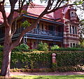
The suburb of Centennial Park sits on the western fringe of the parkland and features quality houses on large blocks as well as large multi-unit buildings developed in the 1960s to 1980s on Cook Road. The suburb developed as a result of a decision to sell off land adjacent to the park to raise money for the park development. One hundred and one acres of land were subdivided in 1904. To ensure high standards of residential development, certain requirements were imposed. No wooden buildings or terrace homes were allowed; brick or stone were mandated, with tile or slate roofs. Between 1905 and 1925, a wide range of substantial, quality homes were built, featuring a mixture of Federation, Arts and Crafts, Victorian and Old English styles. Homes are centred mainly on Martin Road, Robertson Road, Lang Road and Cook Road.[2]
Notable houses[edit]
- Patrick White house, in Martin Road (also known as Highbury), was the home of writer Patrick White for many years, until his death. It is heritage-listed.[3]
- The Crossways, Martin Road, is an example of the international Arts and Crafts style. It was designed by Waterhouse and Lake and built in 1908. The Crossways was built as part of the subdivision of 1904 that created the suburb, and was the home of physician/surgeon Dr Craig Gordon. It is heritage-listed.[4]
- Devon, in Martin Road, is a distinctive example of the Arts and Crafts style. It is heritage-listed.[5]
- Murrulla, in Martin Road, is a two-storey home in the Federation Anglo-Dutch style, which is rare in residential architecture. The first known occupant was Solomon Cohen in 1908. The house has a state heritage listing.[6]
- The Bungalow, in Robertson Road, is a heritage-listed home in the California Bungalow style.[7] It has a skillion roof that distinguishes it from other bungalows like the ranger's cottage in the park.
- Devoncliffe, Lang Road, is a two-storey mansion designed in the Federation Free Classical style and made of sandstone. It was built c.1910 and is heritage-listed.[8]
- Italianate home, in Lang Road, was built c.1890 and features polychrome brickwork that was popular at the time. It is an example of the architecture of the Boom Era, when people were building elaborate homes to display their wealth. It is listed on the Register of the National Estate.[9]
- Stanton Hall (also known as Babington), Martin Road, is an example of the Inter-War Free Classical style, and is heritage-listed[10]
Climate[edit]
| Climate data for Centennial Park Round House | |||||||||||||
|---|---|---|---|---|---|---|---|---|---|---|---|---|---|
| Month | Jan | Feb | Mar | Apr | May | Jun | Jul | Aug | Sep | Oct | Nov | Dec | Year |
| Average high °C (°F) | 26.1 (79) |
26.0 (78.8) |
24.9 (76.8) |
22.4 (72.3) |
19.7 (67.5) |
17.2 (63) |
16.7 (62.1) |
18.1 (64.6) |
20.3 (68.5) |
22.3 (72.1) |
24.1 (75.4) |
25.5 (77.9) |
21.9 (71.4) |
| Average low °C (°F) | 17.4 (63.3) |
17.7 (63.9) |
16.2 (61.2) |
13.2 (55.8) |
9.9 (49.8) |
7.8 (46) |
6.5 (43.7) |
7.2 (45) |
9.3 (48.7) |
12.0 (53.6) |
14.1 (57.4) |
16.3 (61.3) |
12.3 (54.1) |
| Source: [11] | |||||||||||||
Gallery[edit]
-
Highbury, former home of Patrick White
References[edit]
- ^ Australian Bureau of Statistics (31 October 2012). "Centennial Park (State Suburb)". 2011 Census QuickStats. Retrieved 29 April 2013.
- ^ Centennial Park Walk. Department of Environment and Planning, New South Wales. 1987. p. 14. ISBN 0-7305-1936-8.
- ^ State Heritage Register
- ^ "Crossways, The". Heritage Listings. NSW Heritage. 3 March 2000. Retrieved 31 August 2010.
- ^ State Heritage Register
- ^ State Heritage Register
- ^ State Heritage Register
- ^ State Heritage Register
- ^ The Heritage of Australia, Macmillan Company, 1981, p.2/66
- ^ State Heritage Register
- ^ "Summary statistics Centennial Park Round House". Bureau of Meteorology. 14 July 2011. Retrieved 17 July 2011.
| Wikimedia Commons has media related to Centennial Park, Sydney. |


