Chiricahua National Monument
| Chiricahua National Monument | |
|---|---|
|
IUCN category V (protected landscape/seascape)
|
|

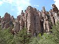
The Balanced Rock formation
|
|

|
|
| Location | Cochise County, Arizona, USA |
| Nearest city | Willcox, AZ |
| Coordinates | 32°00′20″N 109°21′24″W / 32.00569°N 109.35672°WCoordinates: 32°00′20″N 109°21′24″W / 32.00569°N 109.35672°W |
| Area | 11,984 acres (48.50 km2)[1] |
| Created | April 18, 1924 |
| Visitors | 40,646 (in 2013)[2] |
| Governing body | National Park Service |
| Website | Chiricahua National Monument |
Chiricahua National Monument is a unit of the National Park System located in the Chiricahua Mountains of southeastern Arizona. The monument was established on April 18, 1924 to protect its extensive hoodoos and balancing rocks. The Faraway Ranch, which was owned at one time by Swedish immigrants Neil and Emma Erickson, is also preserved within the monument.[3]
Geography[edit]
Located approximately 36 miles (58 km) southeast of Willcox, Arizona, the monument preserves the remains of an immense volcanic eruption that shook the region about 27 million years ago. The thick white-hot ash spewed forth from the nearby Turkey Creek Caldera, cooled and hardened into rhyolitic tuff, laying down almost two thousand feet of dark volcanic ash and pumice, highly siliceous in nature, which eventually eroded into the natural features that we see at the monument today.[4]
In 2008, the Chiricahua National Monument Historic Designed Landscape, covering roughly 80% of the national monument, was listed on the National Register of Historic Places.[5]
Gallery[edit]
-
Stone columns, called hoodoos, are the most common formation in the monument
-

Hoodoos in Totem Canyon
-

The Big Balanced Rock
-

Pinnacle Balanced Rock - Heart of Rocks Loop trail
-

Park road


See also[edit]
References[edit]
- ^ "Listing of acreage as of December 31, 2013". Land Resource Division, National Park Service. Retrieved 2014-03-28.
- ^ "NPS Annual Recreation Visits Report". National Park Service. Retrieved 2014-03-28.
- ^ "Chiricahua National Monument: Nature & Science". National Park Service. Retrieved 2011-07-03.
- ^ "Geology Field Notes: Chiricahua National Monument, Arizona". National Park Service. Retrieved 2011-07-03.
- ^ National Park Service (2009-03-13). "National Register Information System". National Register of Historic Places. National Park Service.
External links[edit]
| Wikimedia Commons has media related to Chiricahua National Monument. |
| Wikivoyage has a travel guide for Chiricahua National Monument. |
- "Chiricahua National Monument". National Park Service. Retrieved 2011-07-03.

| Topics | |
|---|---|
| Lists by states |
|
| Lists by insular areas | |
| Lists by associated states | |
| Other areas | |