San Salvador de Jujuy
| San Salvador de Jujuy | ||
|---|---|---|
| City | ||

(From top to bottom; from left to right) View of the city; Monument to Belgrano; Cathedral of St. Francis; Downtown and Patio of the Cathedral Church.
|
||
|
||

San Salvador de Jujuy
|
||
| Coordinates: 24°11′S 65°18′W / 24.183°S 65.300°WCoordinates: 24°11′S 65°18′W / 24.183°S 65.300°W | ||
| Country | Argentina | |
| Province | Jujuy | |
| Department | Capital | |
| Founded | April 19, 1593 | |
| Government | ||
| • Intendant | Raúl Jorge (UCR) | |
| Area | ||
| • Total | 19 km2 (7 sq mi) | |
| Elevation | 1,259 m (4,131 ft) | |
| Population (2001) | ||
| • Total | 237,751 | |
| • Density | 13,000/km2 (32,000/sq mi) | |
| Demonym(s) | Jujeño | |
| Time zone | ART (UTC−3) | |
| CPA base | Y4600 | |
| Dialing code | +54 388 | |
| Website | Official website | |

San Salvador de Jujuy (Spanish pronunciation: [san salβaˈðor ðe xuˈxui]), commonly known as Jujuy and locally often referred to as San Salvador,[1] is the capital city of Jujuy Province in northwest Argentina. It lies near the southern end of the Humahuaca Canyon where wooded hills meet the lowlands.
Its population at the 2001 census [INDEC] was 237,751 inhabitants. If its suburbs are included, this figure rises to around 300,000.[2] The current mayor is Raúl Jorge.
City information[edit]
The city lies on National Route 9 that connects La Quiaca 289 km (180 mi) with Salta 120 km (75 mi), and it is 1,525 km (948 mi) from Buenos Aires. Tourist destinations not far from the city are Tilcara 84 km (52 mi), Humahuaca 126 km (78 mi), and the Calilegua National Park 111 km (69 mi).
Jujuy is located near the Andes, at the junction of the Xibi Xibi River and the Río Grande de Jujuy, 1,238 meters above sea level. The weather is humid during the summer and dry and cold during the winter. Temperatures vary widely between day and night.
The city is the provincial government, financial and cultural centre. Most administrative offices related to economic activities that take place in other parts of the province are located here; these activities include petroleum extraction and pre-processing, sugarcane and sugar industry (Ledesma), tobacco (El Carmen, 10 km south), steel (in nearby Villa Palpalá), citrus, and fruit and vegetable production for local consumption.
The city has a colonial city centre including the Cabildo, the Cathedral, and colourful Andean carnivals. The population of the city, and of the province in general, has a much more aboriginal character than the rest of the country, reflected in the predominant Quechua, Aymara and Chiriguano people and cultures.
The Gobernador Horacio Guzmán International Airport (IATA: JUJ, ICAO: SASJ) at coordinates 24°24′00″S 65°05′00″W / 24.40000°S 65.08333°W, is 33 km (21 mi) southeast of the city (in Ciudad Perico) and has regular flights to Buenos Aires.
-
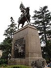
Monument to Manuel Belgrano
-

Belgrano Square and the Government Palace
-

Cathedral of St. Francis
-
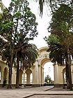
Patio of the Cathedral Church


History[edit]
After previous attempts in 1565 and 1592, the current city was founded as San Salvador de Velazco en el Valle de Jujuy on April 19, 1593, by Francisco de Argañarás y Murguía. The settlement initially developed as a strategic site on the mule trade route between San Miguel de Tucumán and the silver mines in Potosí, Bolivia.
Reaching its peak importance during the colonial period, San Salvador de Jujuy declined to the status of a remote provincial capital after the Argentine Declaration of Independence in 1816. The town became the capital of Jujuy Province when the latter separated from Salta Province in 1834. The 1863 Jujuy earthquake leveled the town, and it recovered slowly in the following decades. Jujuy began to grow following the arrival of the Northern Central Railway in 1900. Its first institution of higher learning, the Economic Sciences Institute, was established in 1959, and was incorporated into the new National University of Jujuy in 1973. The city was the location of a number of Argentine films, including Veronico Cruz (1988) and Una estrella y dos cafés (2005). The city's impoverished Lower Azopardo neighborhood would later give rise to Milagro Sala's Indigenist Tupac Amaru Neighborhood Association.
Climate[edit]
Jujuy has a very pleasant humid subtropical climate (Cwa, according to the Köppen climate classification), mainly because of the altitude. Summers bring warm days at 28 °C (82 °F) and pleasant, nice nights at 16 °C (61 °F) with frequent thunderstorms. The rest of the year is sunny, with delightful falls at about 24 °C (75 °F) during the day and 11 °C (52 °F) at night, crisp, dry winters with warm days of 19 °C (66 °F) and cold nights at 4 °C (39 °F), and sunny springs with warm days (26 °C, or 79 °F) and cool nights (11 °C, 52 °F). During heat waves, temperatures can sometimes reach 35 °C (95 °F) but these are not frequent and nights always bring significant cooling, as opposed to many low-lying areas in Northern Argentina. During the winter, temperatures can reach −7 °C (19 °F) and snow, although rare, may fall sometimes. Precipitation is about 800 mm, which fall in the form of thunderstorms during the warmest months. The highest temperature recorded was 42.0 °C (108 °F) on December 11, 2010 while the lowest temperature recorded was −6.9 °C (20 °F) on August 14, 1978.[3]
| Climate data for San Salvador de Jujuy (extremes 1970–present) | |||||||||||||
|---|---|---|---|---|---|---|---|---|---|---|---|---|---|
| Month | Jan | Feb | Mar | Apr | May | Jun | Jul | Aug | Sep | Oct | Nov | Dec | Year |
| Record high °C (°F) | 40.2 (104.4) |
38.4 (101.1) |
36.0 (96.8) |
34.5 (94.1) |
33.9 (93) |
34.1 (93.4) |
39.9 (103.8) |
38.0 (100.4) |
41.3 (106.3) |
40.5 (104.9) |
41.7 (107.1) |
42.0 (107.6) |
42.0 (107.6) |
| Average high °C (°F) | 29.6 (85.3) |
28.9 (84) |
27.0 (80.6) |
24.0 (75.2) |
21.3 (70.3) |
19.2 (66.6) |
20.3 (68.5) |
23.3 (73.9) |
25.0 (77) |
29.0 (84.2) |
30.0 (86) |
30.3 (86.5) |
25.7 (78.3) |
| Daily mean °C (°F) | 23.5 (74.3) |
22.6 (72.7) |
21.3 (70.3) |
18.4 (65.1) |
14.9 (58.8) |
11.5 (52.7) |
12.0 (53.6) |
15.0 (59) |
17.3 (63.1) |
21.6 (70.9) |
23.1 (73.6) |
23.7 (74.7) |
18.7 (65.7) |
| Average low °C (°F) | 18.3 (64.9) |
17.4 (63.3) |
16.9 (62.4) |
14.7 (58.5) |
9.9 (49.8) |
5.9 (42.6) |
5.7 (42.3) |
8.4 (47.1) |
10.2 (50.4) |
14.6 (58.3) |
16.9 (62.4) |
17.9 (64.2) |
13.1 (55.6) |
| Record low °C (°F) | 9.4 (48.9) |
7.5 (45.5) |
7.7 (45.9) |
1.5 (34.7) |
−1.9 (28.6) |
−6.0 (21.2) |
−5.6 (21.9) |
−6.9 (19.6) |
−1.8 (28.8) |
1.8 (35.2) |
4.2 (39.6) |
8.5 (47.3) |
−6.9 (19.6) |
| Average precipitation mm (inches) | 191.2 (7.528) |
140.6 (5.535) |
141.9 (5.587) |
59.1 (2.327) |
8.7 (0.343) |
1.9 (0.075) |
5.9 (0.232) |
5.4 (0.213) |
3.0 (0.118) |
22.5 (0.886) |
58.2 (2.291) |
139.3 (5.484) |
777.7 (30.618) |
| Average precipitation days | 13 | 12 | 16 | 10 | 4 | 3 | 3 | 2 | 2 | 4 | 7 | 11 | 87 |
| Average relative humidity (%) | 76 | 78 | 82 | 83 | 80 | 79 | 72 | 63 | 56 | 56 | 64 | 71 | 72 |
| Mean monthly sunshine hours | 229.4 | 194.9 | 176.7 | 171.0 | 195.3 | 150.0 | 207.7 | 217.0 | 204.0 | 204.6 | 207.0 | 229.4 | 2,387 |
| Percent possible sunshine | 55 | 53 | 46 | 49 | 57 | 47 | 62 | 62 | 57 | 52 | 51 | 54 | 54 |
| Source #1: Servicio Meteorologico Nacional,[4] Oficina de Riesgo Agropecuario (record highs and lows)[3] | |||||||||||||
| Source #2: UNLP (sun only)[5] | |||||||||||||
See also[edit]
References[edit]
- ^ South American Handbook 2009 ISBN 978-1-906098-36-0 p.173
- ^ Indec:Instituto Nacional De Estadistica Y Censos De La Republica Argentina
- ^ a b "Jujuy, Jujuy". Estadísticas meteorológicas decadiales (in Spanish). Oficina de Riesgo Agropecuario. Retrieved June 12, 2015.
- ^ "Datos Estadísticos (Período 1981-1990)" (in Spanish). National Meteorological Service of Argentina. Retrieved August 23, 2012.
- ^ "Datos bioclimáticos de 173 localidades argentinas". Atlas Bioclimáticos (in Spanish). Universidad Nacional de La Plata. Retrieved June 19, 2015.
External links[edit]
| Wikimedia Commons has media related to San Salvador de Jujuy. |
- (Spanish) Municipal site
- (Spanish) City tourist office
- (Spanish) Digital Newspaper